Pulsing With Life
Part of the Water: H2O = Life exhibition.
Beautiful Empire
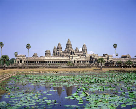
Founded some 1,200 years ago, the Khmer Empire covered much of Southeast Asia for six centuries. The kingdom, based near Cambodia's "great lake," or Tonle Sap, relied on the lake's plentiful supply of fish and on rice grown in the abundance of water. With the Empire's collapse in 1431, the Khmer people left behind canals, reservoirs and dozens of temples, including Angkor Wat, one of the world's most spectacular ancient monuments. King Jayavarman VII, depicted in the sculpture, oversaw the rebuilding the city of Angkor in the wake of its destruction by invaders in the year 1177.
Angkor Wat, the world-famous temple complex built almost 900 years ago, is visible here surrounded by a rectangular moat. The faint square just north of the temple marks the central city of Angkor. The long rectangle west of Angkor is a storage reservoir eight kilometers (five miles) long.
Tonle Sap is the largest freshwater lake in Southeast Asia. Its rising and falling water levels shape Cambodia's geography, culture and economy.
Water from the Mekong River reverses direction and begins flowing up the Tonle Sap River during the intensely rainy monsoon season.
Tonle Sap's shoreline advances inland more than 40 kilometers (25 miles) during the wet monsoon season between June and October. The floodwaters nourish dozens of bird and fish species as well as extensive rice farms.
The source of the Mekong River lies 2,400 kilometers (1,500 miles) north of Tonle Sap, in the Himalaya Mountains of China. Dams built in Laos and China since the 1990s have started interfering with the natural water flows that sustain Tonle Sap's living systems.