7. Archaeology of the Western Venezuelan Llanos. The Barinas Project
Authors: Jennifer Beckmann, Charles S. Spencer, Elsa M. Redmond
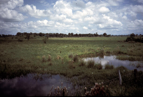
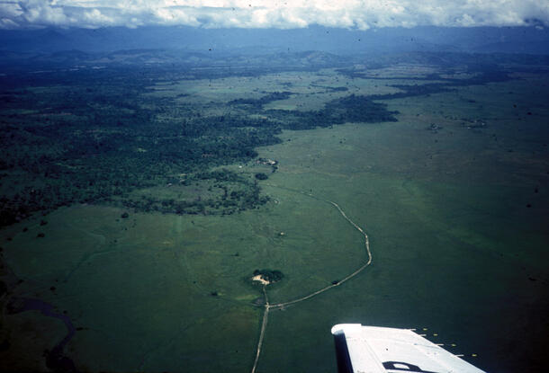
The state of Barinas, in western Venezuela, is home to a great deal of archaeological information about the prehispanic chiefdoms that existed there from as early as the 500s CE. With its numerous rivers, including the Canaguá, and diverse geography ranging from Andean mountain peaks to low, wet grasslands, this region has attracted explorers and scholars since the Europeans first arrived in the 16th Century. While research has been done since the 1960s on various aspects of prehispanic life in western Venezuela, no archaeologists had explicitly focused on the organization and development of chiefdoms in Barinas until Charles Spencer and Elsa Redmond commenced the Barinas Project in 1983.
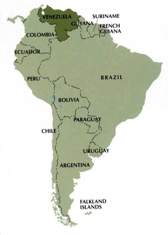
Spencer and Redmond decided to compare two regions, the Andean piedmont and the high llanos, or savanna grasslands. By investigating the prehistory of these two different geographical areas, the archaeologists hoped to trace the development of prehispanic chiefdoms in Barinas. Prehispanic chiefdoms are societies with centralized political authority and institutionalized social differentiation, but lacking the internally specialized, bureaucratic government characteristic of a state. The chiefdom can also be seen as the intermediate step between an egalitarian society and a state, though it must be emphasized that the chiefdom is its own political entity and not simply a transitional phase.
Ethnohistory and Archaeology of Flourishing Venezuelan Chiefdoms
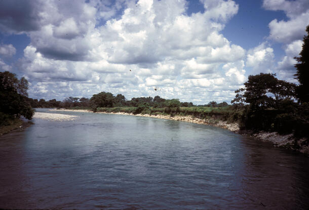
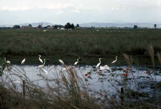
When European explorers first visited Barinas in the 1500s, they found large, complex chiefdoms flourishing throughout the llanos region. The Caquetío, in particular, stand out because of the impressive size, density, and organization of their group of chiefdoms. Numerous, well-fortified villages were united under one paramount Caquetío chief. Evidence of social differentiation was reflected in the size of a man's house, his number of wives, and the quality and number of bead necklaces he wore. The Caquetío used irrigation methods to take maximum advantage of the fertile land, and they interacted with other cultural groups through warfare and trade. That the Caquetío chiefdoms were flourishing as they were in the 16th Century is impressive enough. But, as Spencer and Redmond discovered, chiefdoms as advanced and complex as the Caquetío flourished in Barinas for a thousand years prior to their discovery by the Europeans.
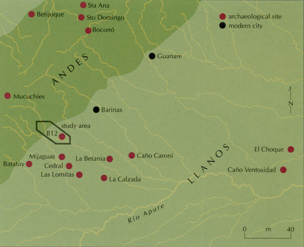
Spencer and Redmond integrated the ethnohistoric information provided by the 16th Century European explorers into their own survey and excavation during the five-year Barinas Project and ensuing research. The survey region overlapped the high llanos and the Andean piedmont, and data were collected on different levels of cultural organization, including household, community, regional, and interregional levels.
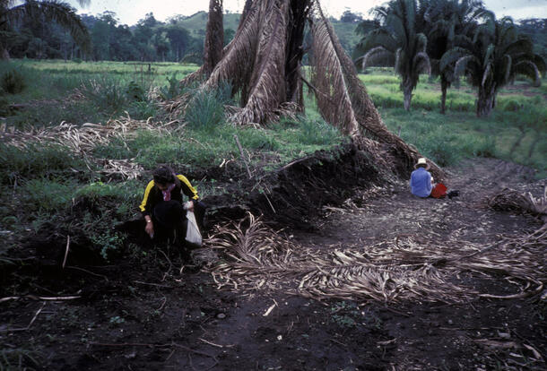
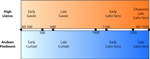
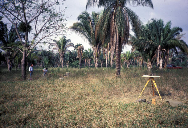
The fieldwork was a three-phase process. First, from 1983-5, Spencer and Redmond conducted an intensive regional survey in which they located 103 sites. Then, in 1986 and 1988, they excavated 201 test pits at 10 of these sites. Finally, three areas of horizontal excavation were carried out at El Gaván, the largest prehistoric settlement and first-order center of the Late Gaván period chiefdom, in 1988. Through their fieldwork and research, Spencer and Redmond were able to discern a four-phase ceramic chronology for prehistoric occupations in both the piedmont and llanos regions.
Prehispanic Chiefdom Development: The Archaeological Evidence
The earliest evidence of occupation in both the piedmont and llanos regions dates from 300-550 CE. Only four habitation sites were found from this early period. It is in the later occupation (550-1000 CE), when the number of sites grows to 32 in the llanos and six in the piedmont, that we see the formation of prehispanic chiefdoms.
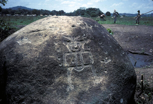
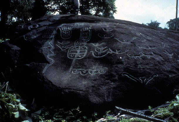
In the piedmont region, small Late Curbatí period sites were found in both the Canaguá and Curbatí valleys. Here, Spencer and Redmond found pottery resembling that of other Andean regions, not the llanos. They also found petroglyphs at the two habitation sites in the Curbatí valley, which, along with other petroglyphs that had already been discovered, may have marked an important trade route between the llanos and the high Andes.
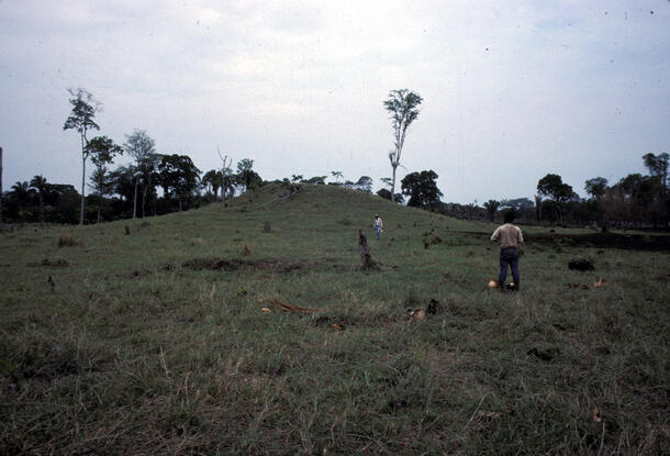
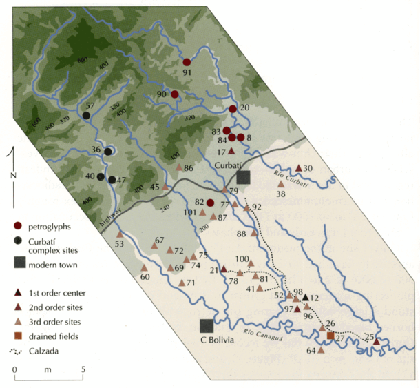
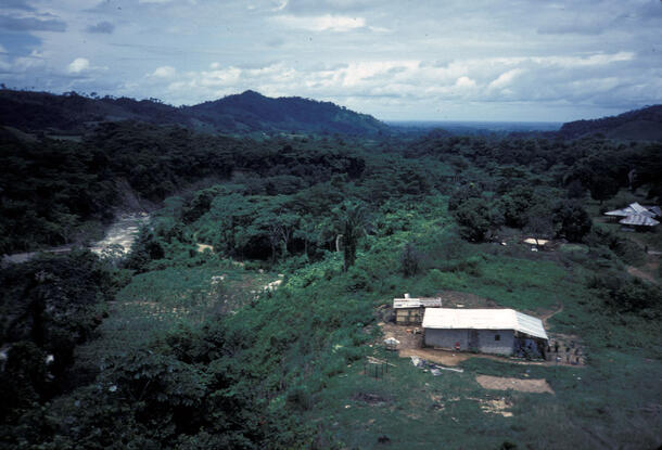
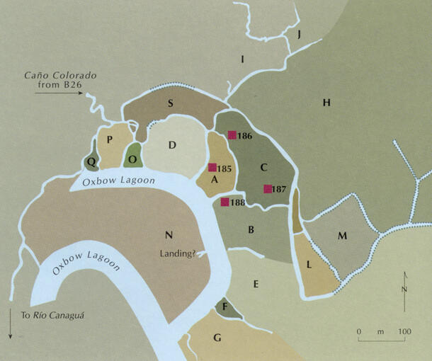
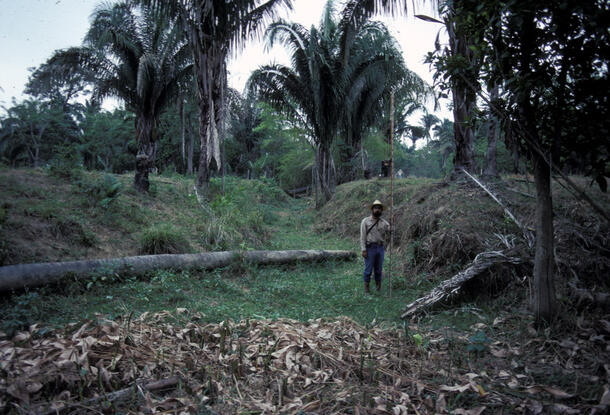
The 32 Late Gaván period sites clearly represented a regional settlement hierarchy, one of the main characteristics of a chiefdom. At the top of the hierarchy is the first-order center, or El Gaván, where Spencer and Redmond carried out their horizontal excavations. El Gaván, which covers 33ha, consists of two large mounds flanking a plaza whose initial construction dates to 550 CE. The site also encompasses multiple housemounds and domestic debris collected during survey and excavation. But perhaps the most outstanding feature of El Gaván is the earthwork surrounding it: an oval-shaped calzada with interior calzadas as well as postmolds that are evidence of a palisade-type fortification. The calzada system served to fortify the Gaván site as well as connect it to other sites within the chiefdom.
Spencer and Redmond found five second-tier and 26 third-tier sites that were part of the Gaván chiefdom. The second-tier sites included small plazas and mounded architecture, while the third-tier sites were small villages that lacked mounded architecture.
Life in the Chiefdom: Food, War, Trade, and the Social Ladder
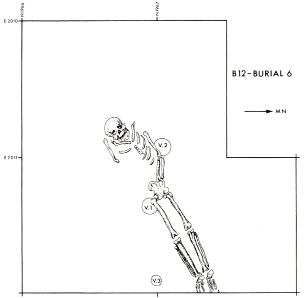
The same qualities that characterized the 16th Century Caquetío group of chiefdoms were found to date back to El Gaván and its subordinate villages. Social differentiation was evidenced by the variation in house size, and also reflected in the burials that were found. Of the eight total burials, four were disarticulated skeletal remains found in public areas. Four other burials were fully laid-out skeletons, some of which were accompanied by vessels or other offerings, associated with residential remains.
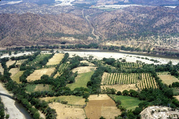
Agricultural sophistication and intensification, another aspect of the prehispanic chiefdom, is clearly and impressively evidenced by the 35ha drained field system at La Tigra that is connected to the calzada network and a third-order village site. The canals created here would have allowed for two harvests per year, thus creating a surplus that could have supplied the first-order center with food in times of warfare while reinforcing the subordinate relationship between El Gaván and the third-order site.
Indeed, warfare was a part of life in the Late Gaván chiefdom, as is evidenced by the defensive calzada, the partial skeletons found in non-residential fill, and the remains of a widespread conflagration that took place when the site was abandoned. Such hostilities are evident only at El Gaván, not at the lower-tier sites, further emphasizing the first-order center as the nucleus of the chiefdom. A final important aspect of the chiefdom is its trade relationships, and El Gaván clearly had strong ties to foreign groups. Exotic artifacts and a variety of polished stones were found that were not native to the llanos but to the Venezuelan Andes and even farther away. Perhaps the goods would have been transported through the piedmont, and followed the marked route of the petroglyphs that have been found there. Trade seems to have been a significant factor in the development of this prehispanic chiefdom as early as the 6th Century CE.
There is much research that needs to be done in order to complete the picture of prehispanic chiefdom development. In particular, Spencer and Redmond suggest that more housemounds and burials should be excavated. They also encourage the study of other river valleys adjacent to the Canaguá, such as Rafael Gasson's ongoing investigations in the Ticoporo and Acequia drainages to the southwest, for an enriched comparison among llanos chiefdoms. While the Barinas Project has served to fill a gap in scholarship, it has raised new questions that can help guide future research in this region.
Bibliography
Redmond, Elsa M. and Charles S. Spencer | |
1994 |
Pre-Columbian Chiefdoms. National Geographic Research & Exploration 10(4):422-439. |
Spencer, Charles S. | |
1987 |
Rethinking the Chiefdom. In Chiefdoms in the Americas, edited by R.D. Drennan and C.A. Uribe, pp.369-390. University Press of America, Lanham, Maryland. |
1994 |
Factional Ascendance, Dimensions of Leadership, and the Development of Centralized Authority. In Factional Competition and Political Development in the New World, edited by Elizabeth M. Brumfiel and John W. Fox, pp.31-43. Cambridge University Press, Cambridge. |
Spencer, Charles S. and Elsa M. Redmond | |
1992 |
Prehispanic Chiefdoms of the Western Venezuelan llanos. World Archaeology 24(1):134-157. |
Spencer, Charles S., Elsa M. Redmond and Milagro Rinaldi | |
1994 |
Drained Fields at La Tigra, Venezuelan Llanos: A Regional Perspective. Latin American Antiquity 5(2):119-143. |
Additional Reading
Kirkby, A. | |
1973 |
The Use of Land and Water Resouces in the Past and present valley of Oaxaca, Mexico. Memoirs of the Museum of Anthropology No. 5. University of Michigan, Ann Arbor. |
Rouse, I.B. and J.M. Cruxent | |
1963 |
Venezuelan Archaeology. Yale University Press, New Haven. |
Zucchi, Alberta | |
1985 |
Recent Evidence for Pre-Columbian Water Management Systems in the Western Llanos of Venezuela. In Prehistoric Intensive Agriculture in the Tropics, edited by I.S. Farrington, pp.167-180. BAR International Series 232. British Archaeological Papers, Oxford. |