The rock that paves Mars's vast Arabia Terra region is very ancient and cratered. Now, the powerful HiRISE camera on the Mars Reconnaissance Orbiter has taken striking images of wind-eroded outcrops on some of the crater floors. The outcrops' sedimentary layers appear to have built up with rhythmic regularity, suggesting that random, catastrophic events such as floods or volcanic eruptions did not create them.
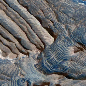
So what did? HiRISE's high-resolution images allowed Mars researchers to use investigative techniques practiced by Earth geologists. A team of scientists from the California Institute of Technology, the U.S. Geological Survey, and the University of Arizona reconstructed a 3D topographic map of a hilly region in Arabia Terra. They used this map to measure the height and pattern of the rock layers.
The results suggest that regular climate events built up the layers in stages. The best candidate for what would set off such cycles is the shift of Mars's tilt on its axis, which varies by a few degrees on a 100,000-year rhythm. These types of orbital changes on Earth induce periodic ice ages due to the planet's position relative to the Sun.
See more of HiRISE's images—including a movie of the 3-D map—in the latest AMNH Astro Bulletin.