A Day at the (Barrier) Beach: My Expedition to Sandy Hook
Part of Hall of Ocean Life.

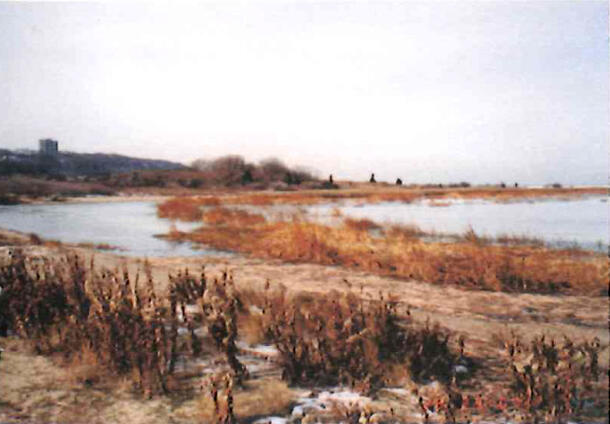
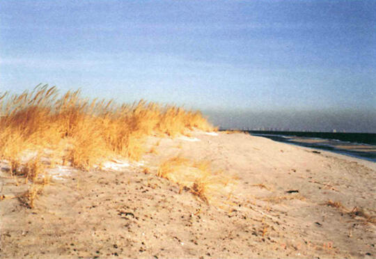
Last June, I eagerly joined an expedition to Sandy Hook sponsored by the New Jersey Marine Science Consortium. I expected it to be a combination of a day at the beach and an educational orientation to oceanography. On the designated day, my mother drove me to the rendezvous point, Building #205, Fort Hancock, Sandy Hook. On a map, Sandy Hook looked like a curved, brown finger protruding from the northeast coast of New Jersey, across from the Atlantic and Navesink Highlands. After crossing the bridge into Sandy Hook, we drove north towards Fort Hancock. I noticed the calm bay waters on one side of the road and the roaring ocean on the other. Instead of just miles of sandy beaches, I saw contrasting vegetation -- from seaweed on the beach to eastern red cedars, clumps of poison ivy, tall switch grass, Virginia creeper, and even prickly pear cacti. By the time we arrived at Fort Hancock, we had passed flat beaches, forests, freshwater ponds, saltwater marshes, and desert-like sand dunes.
In the Fort Hancock complex, we hurried past the oldest working lighthouse in America, rows of military housing, and a Coast Guard Station until we found my destination, Building #205, the marine science laboratory. I sensed that Fort Hancock must have played an important role in protecting the New York Harbor because of its strategic location, but at that time I was more interested in its natural history than in its maritime or military history.
At Building #205, I met the other members of my team, three Brookdale Community College students. I also met Bob, a one-legged lab technician with a colorful past as a lobster fisherman. He detailed our expedition plan: two teams of students would visit Plum Island and the Critical Zone, locations on Sandy Hook, record observations about the physical patterns of this barrier island, and take water samples from both the Atlantic Ocean and the Sandy Hook Bay.
Before we set out, Professor Townsend E. Weeks of the Marine Consortium lectured us on the characteristics of Sandy Hook, a typical barrier island. A "long, narrow island parallel to the shoreline," a barrier island is created by beach erosion and sediment transported by longshore currents(see Diagram 1b). Longshore currents flow parallel to the shore and are caused by waves striking the coast at an angle. A barrier island has a natural defense against erosion: it moves.
According to Professor Weeks' "LUST Theory," a barrier island moves "Landward and Upward in Space and Time." Every wave that washes up the beach picks up some sand. As the wave ebbs, the sand is redeposited in a different place -- a process called littoral drift (see Diagram 1c).
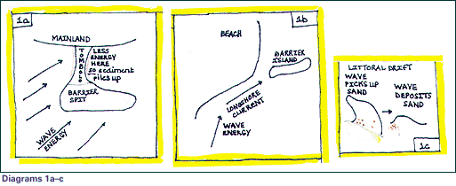
At Sandy Hook, the beaches at the Hook's northern tip have increased in size, while the southern beaches have eroded rapidly. Without human interference, littoral drift would eventually change the shape and location of a barrier island, even moving it toward the mainland. Over the last 250 years, Sandy Hook has been two and three separate islands, and now it is technically a "barrier spit," not an island. It is connected to the beaches along Route 36 South by a "tombolo," a sandy bridge created by the refraction of incoming waves around the island (see Diagram 1a)
As wave energy slacks and sediment piles up, a spit is formed. A seawall and roads now anchor the Sandy Hook tombolo from being swept away.
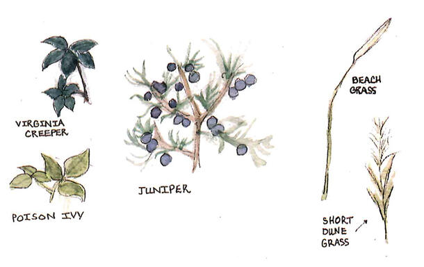
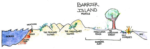
The morphology of Sandy Hook, like all barrier islands, follows a natural progression, starting at the ocean and the beach, and followed by primary dunes, the first line of defense against the ocean. These dunes are formed by a slow buildup of sand around obstacles on the beach, like grass, driftwood or shells. Hardy, salt-spray-tolerant plants, like beach grass (Ammophila breviligulata), short dune grass (Panicum amarum), poison ivy (Toxicodendron radicans), and Virginia creeper (Parthenocissus quinquefolia), stabilize the dunes with massive root systems and rhizomes, horizontal stems or runners which send out sprouts from their joints. Secondary dunes form when heavy storm waves breach the primary dunes, depositing sand further inland. Secondary dunes contain a wider variety of plant life than primary dunes. Following the secondary dunes is a flat, forested area, creatively known as "the barrier flat." The Sandy Hook barrier flat includes a 264-acre American Holly Maritime Forest, which is over 170 years old, as well as several fresh water ponds.
When a strong wind scours sand down to the water table, saltwater bubbles up, later evaporates, and is eventually replaced by rainwater, creating freshwater ponds less than one hundred yards from the ocean. On the bay side, there are saltwater marshes, such as Skeleton Hill Island on Sandy Hook.
My team of four set off to Plum Island, a freshwater tidal wetland on the bay side. I learned that its name was derived from the plum trees that used to grow there and were harvested by Native Americans.
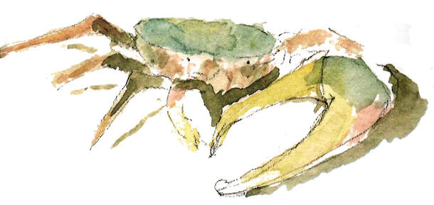
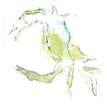
The others in my team were content to observe Plum Island from the road, but I waded through the undergrowth in search of crabs. Plum Island is a haven for many marsh species, including blue, fiddler, and horseshoe crabs. Knee-deep in some sort of weed, I spotted a horseshoe crab.
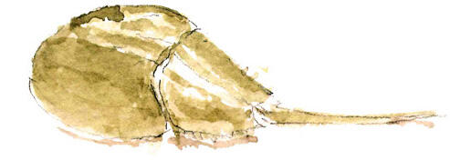
Horseshoe crabs, Limulus polyphemus, are considered living fossils, dating back to the Triassic era. Scientists theorize that the blood of horseshoe crabs inhibit the growth of cancer cells and may be useful as a test for leukemia. At Sandy Hook in May, thousands of shorebirds depend on horseshoe crab eggs to replenish their fat supply before leaving for arctic breeding grounds. If horseshoe crabs become endangered, possibly due to pollution in the bay, a decrease in the population of the crabs -- and consequently of the shorebirds -- would upset the ecological cycle.
My nature walk was interrupted when my teammates shouted at me to stop fooling around in the poison ivy. I extricated myself from the vines and hurried back. Fortunately, I was wearing jeans.
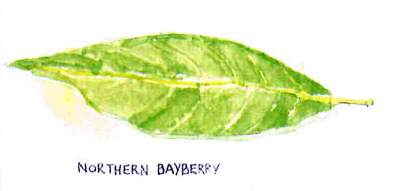
Our second stop was the Critical Zone, north of Plum Island on the ocean side. We parked a quarter of a mile away and walked down a narrow path edged by scraggly Eastern red cedars (Juniperus virginiana) and bayberry bushes (Myrica pensylvanica). Early American colonists came to Sandy Hook to pick bayberries to add fragrance to their candles and juniper berries to make gin.
As we emerged from the forest, I looked up to see a beautiful beach and a deep blue ocean with a view of New York. White mottled birds, piping plovers (Charadrius melodus), screamed and soared in circles above us. The Critical Zone is one of the few remaining nesting habitats for the plovers, and their nesting areas are marked off to protect the birds from human traffic.
The Critical Zone beach was named in 1997 when it was "nourished" by the dumping of several tons of fine sand at the cost of $3.5 million. Today, more than half of this sand has eroded -- the finer, imported sand erodes faster than the native, larger-grained sand.
As I watched the waves, I realized that the question of preserving this beach was much more complicated than I had first thought. Won't the Critical Zone need to be nourished again soon? Is dredging or dumping sand to preserve the beach worth millions of dollars of tax money? What about the need to preserve this habitat for species like the piping plovers or the horseshoe crabs? How much of Sandy Hook's beaches should be closed off to summer visitors to protect rare species? What should be done about human-caused pollution, such as the storm sewer runoff from the Highlands, which is affecting the horseshoe crabs? Considering the LUST theory of littoral drift, maybe if Sandy Hook became an island again, as an alternative to dredging, the sand eroded from one part of the island would be redeposited onto another, changing the shape of the island but preserving the island. As a student, I could only ask these questions and hope to explore the answers later.
Our next stop was the Mid Beach to take our ocean sample. As the clouds darkened overhead, the three college students began to argue over who would take the water sample. "Don't worry, guys," I said cheerfully, "I'd love to do it!"
I took two small glass jars with rubber stoppers and carefully marked them "#1 Ocean" and "#2 Bay." Then I pulled out the pair of hip boots, which came up to my chest. I managed to get them on and then slogged over to the ocean, prudently choosing a position in a few inches of water just in front of a large outcrop of rocks. The ocean roared over the rocks,splashing foam everywhere. I maneuvered the bottle into the foam. After a few waves, the bottle was three-quarters full, and I staggered back to my teammates.
They yelled at me, "You can't do that! All you got was foam with too much oxygen in it. You have to wade farther into the ocean, completely fill the bottle, and cap it underwater! We're trying to measure D.O. -- dissolved oxygen, remember?"
As I turned back to the ocean, they reminded me, "When you're finished, don't waste time-we still have to take the bay sample and get back to the lab before too much oxygen in the bottles dissipates to get an accurate reading."
This time, I boldly waddled across the beach and into the ocean away from the rocks. If I had thought the hip boots felt clumsy on land or in a few inches of water, now, with the water up to my waist, I could hardly move at all. Worse, I had nothing to brace myself against. I leaned over to hold the bottle and stopper underwater, timing my actions so that I could fill the bottle between waves. Cautiously, I was about to push in the stopper, following the correct, scientific procedure, when I looked up and saw a big wave coming. I braced myself for the wave and it rolled passed me, but I forgot about its undertow. Just as I was inserting the stopper into the bottle, the under tow pulled my legs out from under me and I fell face down into cold salty water. I gasped for air and managed to claw my way back to the beach.
My teammates looked down at me disappointedly. "Where's the bottle?" I struggled out my hip boots and smashed my soggy socks into my sneakers. After I poured out the water inside my hip boots, I ruefully realized that they had contained enough water for ten samples.
When we arrived at the bay side, I grabbed our last bottle and, shunning the hip boots, I strode resolutely into the water, soggy sneakers, jeans and all. I was already completely soaked, and I did not need a temperature check to tell me that the bay water was several degrees warmer than the ocean. Unfortunately, the water was also tea-colored and slimy. I took the sample precisely and hurried back to the car, hoping at least this sample would be accurate.
To our chagrin, the car failed to start, so after several failed attempts, we called Bob over the cell phone. "Hurry up and get here! All our oxygen is dissipating! Oh, and bring a towel."
"At least, we can record our on-site observations now," I told my team through chattering teeth. We pulled out the datasheet we'd been told to fill in. "Observations: Weather:" read the first line of the sheet.
"Well," I said, "It's been absolutely freezing at both sites! This feels like January in snow! Write that down."
"Actually, it's really not that cold," my teammates objected. "You'd better let us do this."
"For both sites, we noted "surrounding debris" was "usual": seaweed, driftwood, shells. We described the bay water as "brown." The wind speed was "moderate." But then we had to change the weather because it started to rain heavily.
When we arrived back at the lab, we found that the second team had managed to take an ocean sample but had failed, for unstated reasons, to take a bay sample. Putting our two samples together, we could still compare the bay water with the ocean water. The bay water had a lower pH, but tested for higher ammonia, nitrite, and nitrate than the ocean water. But we never did get accurate dissolved oxygen readings. Our team had been delayed by the stalled car, causing much of our D.O. to dissipate, and the other team had not followed the correct D.O. sample-collecting method. When we asked Bob whether the ocean or the bay was "supposed" to have a higher D.O. reading, he refused to tell us. Someday, I hope to return with proper equipment and take D.O. tests of both sites again. I wonder which would contain more oxygen: the ocean water, with greater turbulence and the resulting aeration, or the bay water, with its abundance of oxygen-producing aquatic plants. Perhaps that most memorable lesson of the day was that expeditions never go as planned.
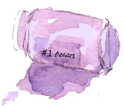
Weeks later, my team revisited our ocean sample site. I trailed several yards behind them, feeling a little embarrassed about my earlier exploits. But this time the pounding rhythm of the ocean seemed gentle and calming. One of the college students ran back to me, laughing and carrying something in her hand. "You're not going to believe this, but look what we found!" She held up a grimy, seaweed-encrusted glass bottle that had been washed ashore. It was totally intact, and I could make out the words "#1 Ocean" on the label.
But we never found the stopper.
References
Cousteau, Jacques-Yves. The Ocean World. New York: Harry N. Abrams, Inc., 1979.
Freeman, Kevin (Ranger). Interview by Madeline Kunsberg. Sandy Hook, New Jersey. December 30, 2000.
Gateway National Recreation Area. Exploring Sandy Hook's Barrier Beach and Salt Marsh. Fort Hancock, New Jersey, 1999.
Hendrix, Marc. Geology 100 Lecture 13 - Beaches and Shorelines. December 18, 1996. University of Montana Department of Geology. Retrieved from the World Wide Web on December 23, 2000: http://www.cs.umt.edu/GEOLOGY/classes/Geol100/L13.html
History of Sandy Hook. Videocassette. United States Department of the Interior, Colorado. 1998.
Macoluso, Robert. Interview by Madeline Kunsberg. Sandy Hook, New Jersey. June 16, 2000.
O'Connell, Tom. Atlantic Horseshoe Crab. February 26, 1999. Maryland Department of Natural Resources. Retrieved from the World Wide Web on December 23, 2000: http://www.dnr.state.md.us/fisheries/education/horseshoe/horseshoefacts.html
Stalter, Richard, et al. Sandy Hook. June 26, 2000. Torrey Botanical Society. Retrieved from the World Wide Web on December 22, 2000: http://torreybotanical.com/ njtofc/sandyhk.html
United States Department of Interior, National Park Service. New Jersey Coastal Heritage Trail. New Jersey Division of Travel and Tourism. Trenton, New Jersey, 1999.
United States Department of the Interior, National Park Service. Sandy Hook. Sandy Hook Visitor Center. Fort Hancock, New Jersey, 1999.
Weeks, Townsend E. History of Oceanography. Unpublished paper, June 2000.
Weeks, Townsend E. Interview by Madeline Kunsberg. Sandy Hook, New Jersey. June 16, 2000.