In the wake of the devastating earthquake that struck Haiti last year, a group of U.S. scientists flew to Port-au-Prince to complete the first technical survey of the city’s geology. A film crew from Science Bulletins, the Museum’s innovative online and exhibition program, joined them to document the fieldwork, producing an Earth Bulletin now on view in the David S. and Ruth L. Gottesman Hall of Planet Earth and online on the Museum’s website.
“The earthquake in Haiti was such a momentous event that we felt we had to talk about the science behind it,” says Edmond Mathez, curator in the Museum’s Department of Earth and Planetary Sciences and the curator for Earth Bulletins.
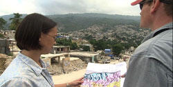
Hundreds of thousands of Haiti’s earthquake victims died in building collapses, but not simply because of poor construction or materials. A huge hurdle to mitigating seismic hazards in Haiti has been that builders worked without information about the area’s underlying rock. Different rock types will magnify the shaking of a quake to different degrees, so understanding the geologic composition of an earthquake zone is crucial to designing buildings that can compensate for those effects. But as of 2010, no modern geologic map of Port-au-Prince existed.
With the city struggling with a cholera epidemic and bracing for a national election, November 2010 wasn’t the easiest time to travel to Port-au-Prince. But the scientific team organized by geophysicist Eric Calais of Purdue University, who was appointed to the task by the United Nations, was committed to finishing their survey before reconstruction began. The researchers fanned out across the city with maps and local engineers, seeking areas where destruction had exposed the earth beneath the urban concrete. Using sledgehammers and basic vibration sensors, they measured how much the ground amplified force. Weeks of work resulted in a map that can be used to develop building codes and other guidelines for safer construction.
On January 12, 2011, the one-year anniversary of the quake, scientists handed over the updated map to Haitian authorities.
Click here to watch this Earth Bulletin.
A version of this story originally appeared in the Summer issue of Rotunda, the Members’ magazine.