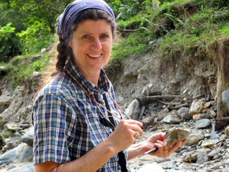
Last month, Museum Curator George E. Harlow wrote for The New York Times’ “Scientist at Work” blog while unearthing clues from past geologic traffic accidents — remnants of tectonic plate collisions, including jade — during field work in Guatemala funded by the Stavros Niarchos Foundation award through the American Museum of Natural History. Read about the first part of his trip on The New York Times and the rest below.
November 8
From our home-away-from-home at Hotel Pasabien, we drive east beyond Los Amates to search for samples of basaltic rocks to evaluate their origin among several possibilities: mid-ocean ridge, island arc, ocean island, or spreading behind island arcs. Now we have our field assistant (jefe del campo) Carlos Gonzales with us and his sidekick Rolando, who will guard our truck. North of Los Amates are serpentinized mantle-like rocks associated with the passage of the Caribbean plate past central Guatemala, but the origin of these rocks is not absolutely clear. Driving through flat cattle lands toward the mountains, the first outcrops consist of gray-green serpentinite with dikes of basaltic rock, just what we were hoping to find. We sample both rock types because we need to know the origin of both. We continue north along the road seeing more serpentinite. Finally, we reach a gate and someone who tells us we cannot go further. Retracing our tracks, we find a stream with some amphibole-rich rocks, which may have been basalts prior to metamorphism, so we collect these too.
Another target is an area of basaltic rocks south of the Motagua River at Jubuco which requires returning to Los Amates and finding the bridge across the river. After a stop for snacking in lieu of lunch, we are directed to a pair of bridges (road and railroad) that have been washed out. We learn the other side is largely cut off from transportation and commerce except what can be carried across a temporary footbridge. So much for Jubuco.
We turn our attention to another road heading north, up the Río La Pita, to check a wedge of amphibolites of unknown affinity based on the geological maps. Driving to the end of the track, we walk up the stream and start finding beautiful blocks of garnet amphibolite, a black rock dotted with red-orange garnets, that were likely basalts metamorphosed by collisional burial—these can be assessed for conditions of metamorphism and possibly dated, as well as their origin. Further up are white marbles with sausage-like inclusions of the black rocks. Samples of these should help understand how the La Pita formation relates to the rest of the area. We return to Pasabien in the dark, essentially white-knuckle driving.
November 9
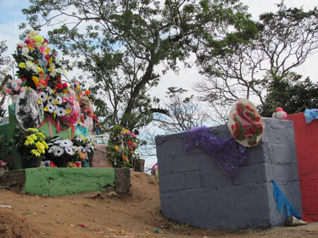
There is a group of teenage students now staying at Hotel Pasabien, so getting meals has slowed significantly, but we get to see the student dynamic down here as well as watch them watch us. Today we head west on the Atlantic Highway to check out some basalts for post-doctoral fellow Kennet Flores’s study of their origin. Our examination at the first stop near Río Uyus shows a mixture of pillows and non-pillow flows of at least 100 m thickness and well preserved although hydrated rock textures. Traveling further west near Pasasagua we examine heavily folded and deformed basalts or basaltic sediments. Kennet notices the contact with serpentinite were the road cut meets a cut for a side road. Further looking finds a beautiful contact some 10s of meters away. Carlos Gonzales, our jadero and field guide, asks whether we would like to see some jade related rocks nearby up in the Sierra de las Minas. Not ones to turn down such an opportunity, we start driving up a little dirt road, seeing beautiful scenery and outcrops. Hosted in the serpentinite mélange are blocks of white igneous rocks, then garnet amphibolites, before we must go to 4-wheel drive to negotiate very steep ups and downs, while being distracted by the stunning mountain scenery. Finally, at an elevation of about 1000 m we reach our destination in the mountain village El Morro. Walking down a trail we venture into a steep stream valley with rock blocks the size of cars, but we cannot keep up with Carlos and must climb through decomposing granite to find a trail out. Rolando, Carlos’ buddy calls him on his cell phone to arrange a rendezvous. We find a trail that will take us to where Carlos ventured. Sure enough there are blocks of black and avocado-skin colored jade-like rocks which we sample while precariously balanced on boulders in the stream. On leaving we are the main attraction of a group of kids, who we treat with some cookies. A graveyard decorated for “the day of the dead” is as colorfully beautiful as are the mountains.
November 10
Another beautiful day but getting warmer. We turn our attention southward to the Río El Tambor, the type locality for the El Tambor formation, which others have interpreted as an ophiolite. An ophiolite is the description for an exhumed section of altered oceanic crust with the sequence of serpentinte at the bottom, overlying gabbros (coarse basalt), basalt “sheeted” dikes, pillow basalts, and finally sediments including radiolarian chert (fossil rich quartz dominant concretions). Researcher Jinny Sisson had sampled portions that contained minerals indicating relatively high temperature metamorphism: staurolite, kyanite, and garnet. Kennet needs to sample these for his project about origin of the El Tambor formation.
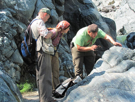
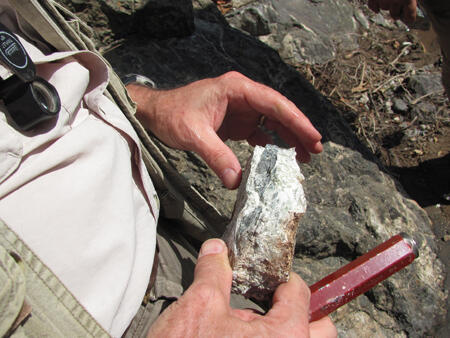
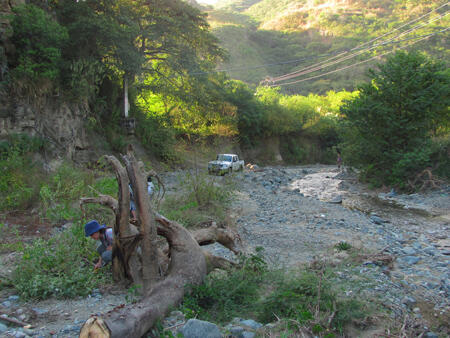
The bridge at Pasabien across the mighty Río Motagua is old but well above the river and was not affected by the floods in May, although we can see a forest of downed and dead trees lining the river’s banks. It is a bumpy ride to Cabañas and then up to El Rosario. We find the dirt track down to the Río El Tambor and show Kennet a narrow gorge with good outcrops and slowly work up the east side. Light colored igneous dikes cut through metamorphosed sediments; we sample both. Further up the river I start noticing rusty foot-long blocks that I recognize as relatively fresh mantle rock—peridotite—incompletely altered to serpentine. These have been washed down from upstream and are good finds as they provide the best evidence for the origin and history of the mantle rocks. At a fording spot, Kennet and Jinny ford the river looking for better samples of El Tambor rocks; just before coming back to the ford Jinny espies garnet bearing rocks and eagerly brings back great samples.
Driving further up the river we make several stops to get more samples of the El Tambor Fm. At one spot we must descend down a long trail to reach the river. There we find serpentinite not shown on the map, and I find blocks of serpentinite filled with veins and altered to the soft mineral talc (or the rock soapstone); I sample them as their compositions are useful for interpreting the composition of the watery fluids that produced them. We push on to Piedras Blancas, at the end of the track, where the El Tambor Fm. is mapped in contact with the next formation. We enter a glad of great ceiba trees that produce an impressive cathedral like space, unlike any we have seen before. Instead of finding the next formation we find more serpentinite and gray-green metamorphosed sedimentary rocks. Returning down the track we encounter a truck full of corn stalks parked in the road; we must wait twenty minutes before the driver returns, so we depart at sunset after another long day.
November 11
One area of serpentinites mapped in the 1970s lies southwest of the main focus of our studies; we have never adequately visited this area, which is along the Río Platanos near the town of Sanarate. We start by walking up Quebrada Salitre, which, according to the map, cuts through serpentinite, and we check for the kinds of rocks there. In addition to serpentinite we find some albite-rich rocks, not unlike found elsewhere in the mixing of high-pressure rocks like jadeitite in serpentinite mélange. Otherwise, there are some cryptic greenstones which require examination back at the Museum. We return to the truck and a tienda (store) for sodas and junk food for lunch.
The next foray is up the Río Platanos to look for other examples of the Platanos Fm., a kind of serpentinite mélange as described in the mapper’s Ph.D thesis (the term did not exist in the 1970s). I find a white vein in serpentinite on the north side of the river – another mystery to be solved back home. We need to ford across the river to get to the next outcrops further upstream. At a smelly spot we call “perro muerto” (dead dog) we find various blocks of limestone(?) and quartz rock (chert?) encapsulated in highly deformed serpentinite, verifying the mapped unit as mélange. Seeing trucks parked in a house nearby we find a road back to our truck and finish another long day as the sun yields another spectacular orange painted sunset on the Motagua River.
November 12
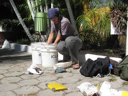
We have made very good progress and have time to start planning our departure. We look for a bank to change currency in Teculután and find that without a bank account, they will not change our dollars. Finally, Kennet prevails on a representative at the third bank to help us get Quetzals to pay our bills. Then we need 5-gallon buckets to ship our rocks home, which has us looking for hardware stores and paint stores. Finally, the biggest paint store in Teculután is a winner with great piles of used buckets, although they are stuck together and will need considerable cleaning.
At around 11 we head east back toward Gualán and then north to La Cuchilla where there is a mapped contact between units we did not have time to visit a few days ago. The contact is between serpentinite and a sliver of the Chuacús Fm, which makes up the bulk of the Sierra de Las Minas, but Jinny suspects the sliver is actually mélange that may contain high-pressure blocks (like jadeitite). If so this would fill in a gap of such rocks north of the Motagua fault. We start our search in a quebrada (stream) that stinks of a pig latrine emptying into it—phew. We find samples of strongly deformed serpentinite and finally some metamorphic volcanic sediments of amphibolite grade (composed largely of amphibole), unlike the Chuacús Fm, and some marbles, thus validating Jinny’s hypothesis.
After making a short stop along Río La Pita, again, to sample what Kennet suspects are basalt dikes in the river, we head to the Quirigua archaeological park, which Kennet and Jamie Newman (my assistant and videographer) have never visited. Here there are some great stelae, giant tombstone like carvings recording great events of the rulers of the Late-Classic Maya site. Fairly well preserved carvings in sandstone show kings who are decked out with jade earspools and belts. We are the last of the few there to leave for a drive in spritzing rain as the sun is again setting.
November 13
Today is our last real day in the field, and the morning is spent sorting through and cleaning our rocks. As soil might bring unwanted organisms into the U.S., cleaning our rocks of any such material is critical to avoiding our rocks being confiscated by customs. Then we sort high priority samples into bags we will take with us versus those that will need to be shipped in the buckets.
At about noon, we head to pick up Carlos and Rolando to go to Pica Pica, a jadeitite location near the Atlantic highway where we will rendezvous with a group of geologists and students coming down after a geological congress in Antigua, the old capital of New Spain. A bit late, the group of 40 or so people arrive, and Kennet and I explain about the rocks at Pica Pica and how they were formed or transformed by oceanic plate subduction some 90 million years ago. Then, with Carlos’ help we enter the area where we jade is usually easily found but is now overgrown with tall grass and weeds after the rainy season. Finally, Carlos reaches a draw where the rocks are richest and I hear the pounding of hard jade under his hammer. After half-an-hour of questions and pounding the eager students and geologists leave clutching blocks of white, green and black jade—a very successful stop for them.
We head to our final target, up the Río Sanarate, some 20 km away, looking again for serpentinite and possible mélange. Our ultimate target is on a road that has been washed out and even our truck is not going to make it, so we turn to a secondary stop a ways back on Quebrada Patache. Here we find more slightly serpentinized peridotite, fine textured greenstones, and a schist that does not match with the geological map. As the sun sets, we thank our Guatemalan field guides, including giving my hammer, chisel, and diminished boots as well as the pay they have earned. Back to Hotel Nuevo Pasabien for our penultimate dinner and celebration prior to tomorrow’s return to Guatemala City and preparations for the flight home.