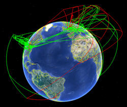
SUPRAMAP, a program that synthesizes large, diverse datasets to help researchers understand the evolution of infectious diseases across hosts and geography, was developed in 2007 by the Museum, The Ohio State University, and the Ohio Superconductor Center. In a recent paper in the journal Cladistics, researchers from these institutions describe how they reconfigured SUPRAMAP’s server to let researchers and public safety officials develop their own applications for the program.
“We now have decoupled the server from the original client to provide a modular web service for POY, an open-source, freely available phylogenetic analysis program developed at the American Museum of Natural History,” said Ward Wheeler, curator-in-charge of scientific computing at the Museum and a co-author on the Cladistics paper. “The web service can be used by other researchers with new ideas, data, and clients to create novel applications.”