


 Biodiversity
 Brain
Brain
 EntomOLogy
 Genetics
 Marine BiOLogy
 MicrobiOLogy
 PaleontOLogy
 ZoOLogy
 AnthropOLogy
 ArchaeOLogy
 Astronomy
 Climate Change
 Earth
Earth
 Physics
 Water
Water
INCA INVESTIGATION
— AN ARCHAEOLOGY GAME —
The ancient Inca city of Huánuco Pampa is located in a cold, remote part of the Andes mountains in Peru. Today, no one lives there. But 500 years ago, it was a thriving city in the Inca empire.

Hi, I'm Craig Morris. One of the most amazing places I've excavated is the ancient Inca city of Huánuco Pampa. It's located in a cold, remote part of the Andes mountains in Peru. Today, no one lives there. But 500 years ago, it was a thriving city in the Inca empire.

The Inca empire stretched more than 3,000 miles along the coast of South America, from Peru through Bolivia and down to Chile.
How do we know what life was once like in Huánuco Pampa? Because hundreds of buildings have been preserved. And archaeologists have excavated dozens of those buildings and unearthed millions of artifacts.
By looking at the maps we created of the buildings and examining the artifacts found near them, my team and I figured out what some of the buildings were once used for. I found some of the places where people lived, where they stored food, where they held festivals, and much more.
It's your turn to be an archaeOLogist!
Play this game to examine clues left behind by the people of this ancient Inca city.
More About the Inca Empire

The Inca empire began more than 600 years ago in the 1400s. With about 10 million people, it was the largest empire in what is now the Americas. It was almost as big as the Roman empire. The Incas conquered many geographic areas and built a sophisticated system of roads to link them to the Inca capital of Cuzco (koos-ko). They united many different groups of people into one empire. But the people maintain their own customs, dress, and languages.
The Inca ruler, known as the “Sapa Inca,” was considered the son of the Sun God. People were divided into noble and commoner classes, which they were born into. The nobles included the important royal families. They controlled the army and ran the separate provinces of the empire. Most people were commoners, like farmers and herdsmen living in villages. Commoners paid taxes by working on projects for the empire. Religious ceremonies and festivals were a big part of life for all people under Inca rule.
In 1532, Spanish forces invaded the Inca territory. They took control of the empire, transforming the Inca cities and traditional way of life.
How to Read a Plan
A “plan” is a type of map that provides a view from above. Like all maps, it gives valuable information about direction, distance, and location.
When archaeologists survey a site where they want to dig, they make a plan to show where the buildings are. When archaeologists excavate an old building, they make a plan to show where the rooms and doors are.
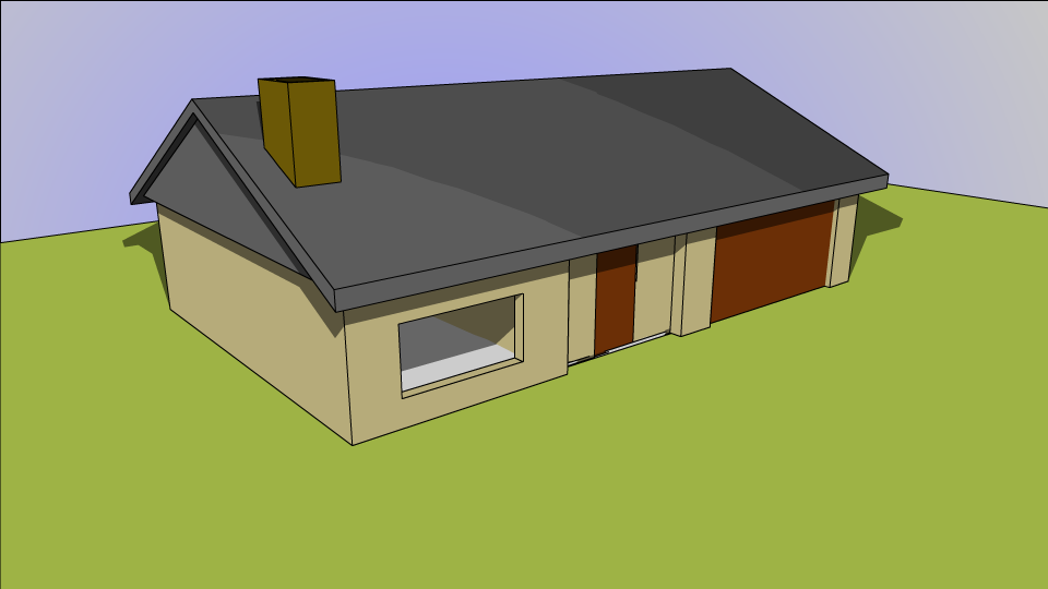

Try to picture what a plan of this house would look like. You have to imagine that you’re looking down on the house, without its roof and walls. The plan would also show you the measurements of the different rooms.
Hard to picture? Just click on the illustration of the house to see for yourself.
Archaeologist Craig Morris studied the ruins of Huánuco Pampa and many other ancient Inca sites. He was a curator at the American Museum of Natural History for over 30 years.
Credits:
Photos: Artifact photos: courtesy of AMNH and Craig Morris; Illustrations: Archaeologist's office: Don Baker/Represented by Kolea Baker; Inca Chronicles: The Royal Library, Copenhagen, http://www.kb.dk/elib/mss/poma/index-en.htm (redrawn by Eric Hamilton); Inca Empire Map: R. Alan Covey