


 Biodiversity
 Brain
Brain
 Genetics
 Marine BiOLogy
 MicrobiOLogy
 PaleontOLogy
 ZoOLogy
 AnthropOLogy
 ArchaeOLogy
 Astronomy
 Climate Change
 Earth
Earth
 Physics
 Water
Water

The Ancient City of
PETRA
Petra was founded over 2000 years ago along the ancient trade routes between Arabia, Egypt, and the Mediterranean Sea. As a center for trade, the capital became very wealthy and powerful. The busy city was bustling with life, full of lush gardens, ornate houses, and markets loaded with exotic goods from India, Arabia, and Egypt.
A Nomadic Beginning
The story of Petra begins with a group of Arabian nomads called the Nabataeans (pronounced "Nab-a-tee-ans"). As nomads, they moved from place to place, living off the land and herding camels, sheep, and goats.
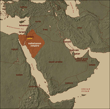
At the height of the Nabataean empire, it included regions of modern-day Jordan, Israel, Egypt, Syria, and northwestern Saudi Arabia.
Over time, their sharp survival skills and knowledge of the desert helped the Nabataeans become successful traders. They gained control of the important trade routes that moved spices and incense from Arabia to Egypt and the Mediterranean Sea.
We know that these nomadic merchants became very rich as desert traders, and slowly gave up their goatskin tents to build the grand houses and monuments that became Petra. But it is a mystery why these people gave up their nomadic life to settle down in one place.

The nomadic Nabataeans settled in the city of Petra.

Today, Bedouins (Arabian nomads) use the same cisterns that the Nabataeans dug about 2000 years ago.
Creating an Oasis in the Desert
Petra grew in the middle of a harsh, barren desert. So how did the ancient city maintain fertile crops, lush gardens, and even public pools for recreation?

Petra's hydraulic system connected canals, cisterns, springs, and fountains throughout the city.
The Nabataeans were experts at surviving in the desert because they knew how to collect and distribute water . An impressive system of rock-cut channels and underground water pipes carried water from permanent springs and seasonal streams.
The Nabataeans also developed a way to collect and store water in watertight holes or cisterns. Hidden underground, these cisterns kept water safe from both evaporation and enemies.

Rock-cut channels along the Siq were used to carry water.

The Nabataeans used underground cisterns to collect and store water.
Controlling Trade Routes
Petra began as a main stopping point for Nabataean and foreign traders. These nomadic merchants carried textiles, incense, spices, ivory, and other precious goods grown or manufactured in Arabia, Asia, and Africa. As the trade market grew, so did Petra.

The Nabataeans controlled trade routes along most of the Incense Road, which stretched from southern Arabia through Petra to Gaza.
Hauling heavy loads across the vast, barren deserts was hard and risky work. For a price, the Nabataeans provided shelter and water at settlements along the trade routes. They also charged tolls to foreign traders for crossing into their territory. All the profits helped pay for the Nabataean state, including the spectacular capital of Petra.
Trade brought more than wealth and exotic goods to Petra. As traders from around the world passed though Petra, they brought new ideas and culture from places like Egypt, China, and Greece. Petra became more than a center of trade—it was also a cultural center of the ancient world.

Left: The 12 zodiac signs are carved in a circle on this terracotta oil lamp. Each sign represents a constellation, like Leo, Gemini, and Capricorn. Right: Handle made of imported Indian ivory.
A City Carved in the Cliffs
Petra is filled with spectacular tombs, monuments, and houses that were carved into the sandstone cliffs. These elaborate structures were chiseled by hand out of the rose-red rocks, then covered with stucco and painted bright colors.

Beautifully carved buildings and monuments are found throughout the city of Petra.
The people of Petra liked to show off their wealth and hired master builders to create these masterpieces. Starting from the top down, builders chiseled the detailed designs by hand right into the sandstone cliffs. The design of the massive columns, grand staircases, and classical statues show the influence of contact with Greece and Rome.
Winding roads, stairways, and water channels were also cut along the natural curves of cliffs and canyons.
But the most breathtaking "road" in the city wasn't carved by humans. The Siq , the narrow, winding gorge that led into Petra, is a natural wonder.

The Monastery (Ed-Deir).

The narrow passage of the Siq.
The Roman Empire Takes Charge
As Petra flourished, the powerful Roman Empire was expanding into the Middle East. The Romans were eager to expand the boundaries of their empire, and in A.D. 106 they took control of the Nabataean capital. It appears the Roman takeover was peaceful, and life in Petra went on without much change. But the empire left an unforgettable mark on the ancient city.

The Roman Empire expanded eastward and took over Petra in A.D. 106.
The distinct Roman style can be seen all over Petra, in the monuments, sculptures, public spaces, and even in the city's design. The Romans built new roads, like the impressive Colonnaded Street that ran through the center of Petra. Lined with massive columns, this long, straight street was unlike anything else in the city.
Rome ruled Petra for the next 300 years, tying the fate of the ancient city to the empire. Eventually, Rome moved the center of trade north. The empire also turned to shipping by sea for much of its trade. Petra's importance in the ancient world began to fade.

This is a marble portrait of Aelius Caesar, the father of the Roman Emperor, Lucius Verus.

This Roman vase with panther-shaped handles was polished and hand-carved from imported marble, a stone prized by the Romans.
Christianity Comes to Petra
In A.D. 330, over 200 years after Rome took control of Petra, a radical event took place in the Roman Empire. The first Christian emperor, Constantine I, moved the main capital from Rome to the city of Byzantium. Rulers of this new Byzantine Empire wanted to spread Christianity.

Rome moved its capital eastward to Byzantium in A.D. 330 to allow for more control over the eastern provinces.
Over the next century, the people of Petra slowly abandoned their pagan gods for this new religion. The city's main cathedral, the Petra Church, was a dazzling symbol of this new era. Even a few once-sacred tombs, like the Urn Tomb, were turned into churches.
The city's power as a trade center had been falling. Trade routes were shifting north or toward the sea. In A.D. 363, Petra suffered another blow when a massive earthquake destroyed many of the city's buildings and its water-supply system.
This natural disaster marked a turning point for the Nabataeans. By A.D. 700, only a few people lived in and around Petra. Over time, the city was lost to the outside world.
More than 500 years would pass before the ancient city was rediscovered by Western explorers.

A stone block inscribed with a cross was found at the Petra Church.

Today, Bedouins inhabit the area of Petra.
TIMELINE
B.C. 200-50
The nomadic Nabataeans settle in Petra.
B.C. 100
Nabataeans gain control of trade in the region.
B.C. 50-A.D. 50
At its height, the city of Petra is the capital of the Nabataean Kingdom. Petra has about 20,000 people.
A.D. 106
Rome takes over Petra. It becomes a Roman province with a Roman governor.
A.D. 330
The first Christian emperor, Constantine I, shifted his capital eastward from Rome to Byzantium.
A.D. 350
Christianity spreads and large churches are built in Petra.
A.D. 363
Earthquake destroys a large portion of Petra.
Late A.D. 300s
Roman rule over Petra collapses.
Early A.D. 600s
Muslim Arabs arrive, and Petra comes under Islamic rule.
A.D. 1812
Western explorers "rediscover" Petra.
A.D. 1993
Petra becomes a national park, a protected archaeological site.
Image Credits:
Monastery in daytime, Photo by Emile Guillemot on Unsplash; Petra basin: courtesy of Jane Taylor, http://www.janetaylorphotos.com; camels drinking at a well / cisterns: courtesy of Jane Taylor, http://www.janetaylorphotos.com; Map of political boundaries: courtesy of AMNH; rock-cut channel along Siq used to divert water: courtesy of Dan Gibson, http://nabataea.net; Cistern: courtesy of Jane Taylor, http://www.janetaylorphotos.com; Map of hydraulic system: courtesy of AMNH; Pin handle with female figure: courtesy of AMNH; Terracotta oil lamp with signs of Zodiac: courtesy of AMNH; map showing an ancient road map of routes: courtesy of AMNH; aerial view of monastery: courtesy of Jane Taylor, http://www.janetaylorphotos.com; The Siq: courtesy of Jordan Tourism Board North America; Map of the city of Petra: courtesy of AMNH; stone male head: courtesy of AMNH; Roman vase with panther-shaped handles: courtesy of AMNH; map of Roman Empire w/ Petra included: courtesy of AMNH; christianity stone: courtesy of Dan Gibson, http://nabataea.net; Bedouins living in the area: courtesy of Jane Taylor, http://www.janetaylorphotos.com; Map showing location of Byzantine Empire: courtesy of AMNH