PLATES on the MOVE GAME
Play this game to explore how plates affect our planet.
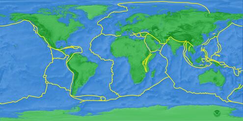
1. Click on an orange marker to explore a place on the map.
2. Examine how tectonic plates are moving there.
3. Answer the question and read more about it!
Mount Everest
HIMALAYAS, NEPAL AND TIBET
Which tectonic plate interaction caused Mount Everest?

slip
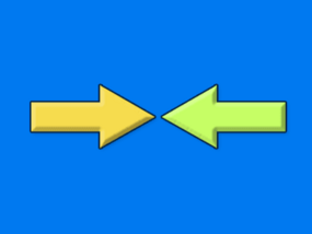
collision
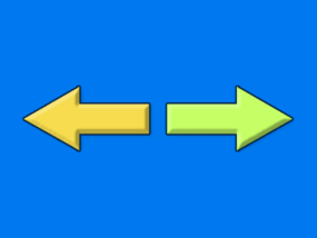
spreading

subduction
About Mount Everest
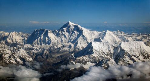
Mount Everest as seen from the air.
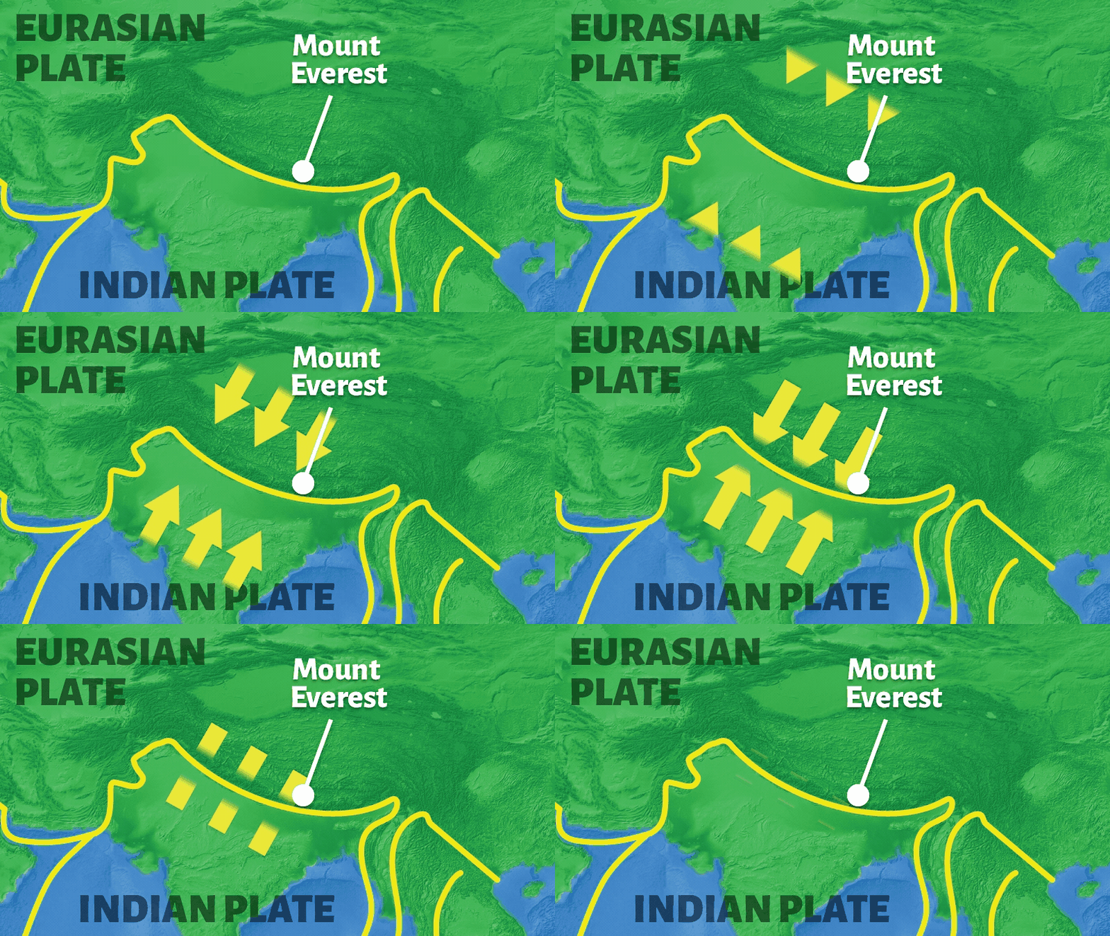
The tallest mountain in the world is still growing. The peak of Mount Everest is rising about one centimeter (about half an inch) each year. In fact, all the mountains along the Himalayas are still growing.
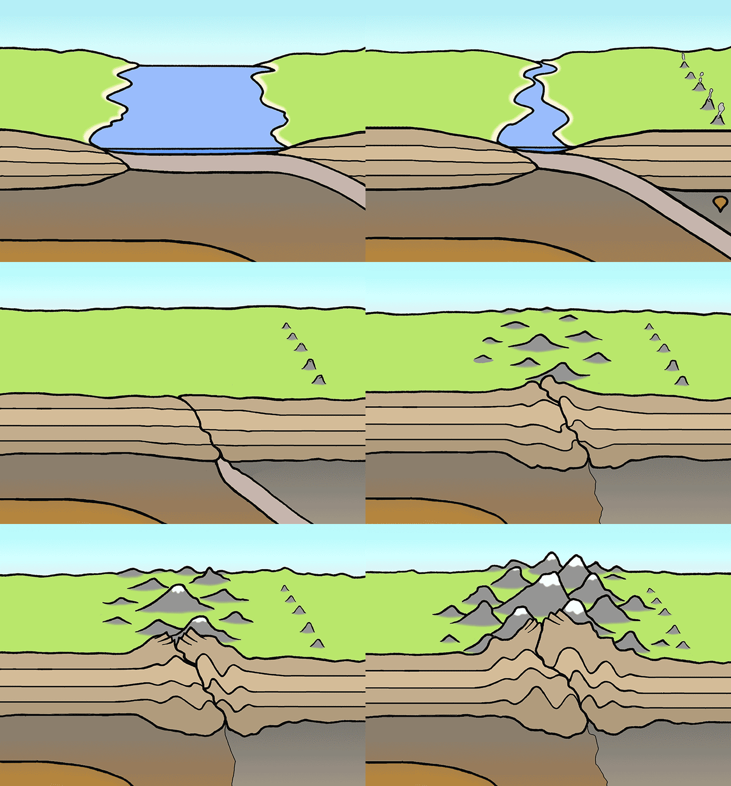
This massive mountain chain began forming about 60 million years ago as the Indian Plate crashed into the Eurasian plate. Both plates are made of continental crust and share a similar thickness and weight. So the two plates began to crumple and push up. The collision is what formed the jagged peaks of the Himalayas.
The Indian Plate is still moving. It is colliding with the Eurasian Plate at a speed of 5 centimeters (2 inches) per year. As long as the two plates collide, the Himalayas will continue to rise.
Mountain building is not the only tectonic activity in the area. The constant pressure between the two plates also causes some of the world’s most powerful earthquakes.
STATS
Event: Mountain formation
Date: About 60 million years ago to the present
Size: The mountain chain is more than 2,400 kilometers (1,500 miles) long, with mountains over 6,000 meters (20,000 feet, nearly 4 miles) tall
Motion: Collision of the Indian and Eurasian plates
Place: Southeast Asia, along the border between India and Tibet
Mount Fuji
JAPAN
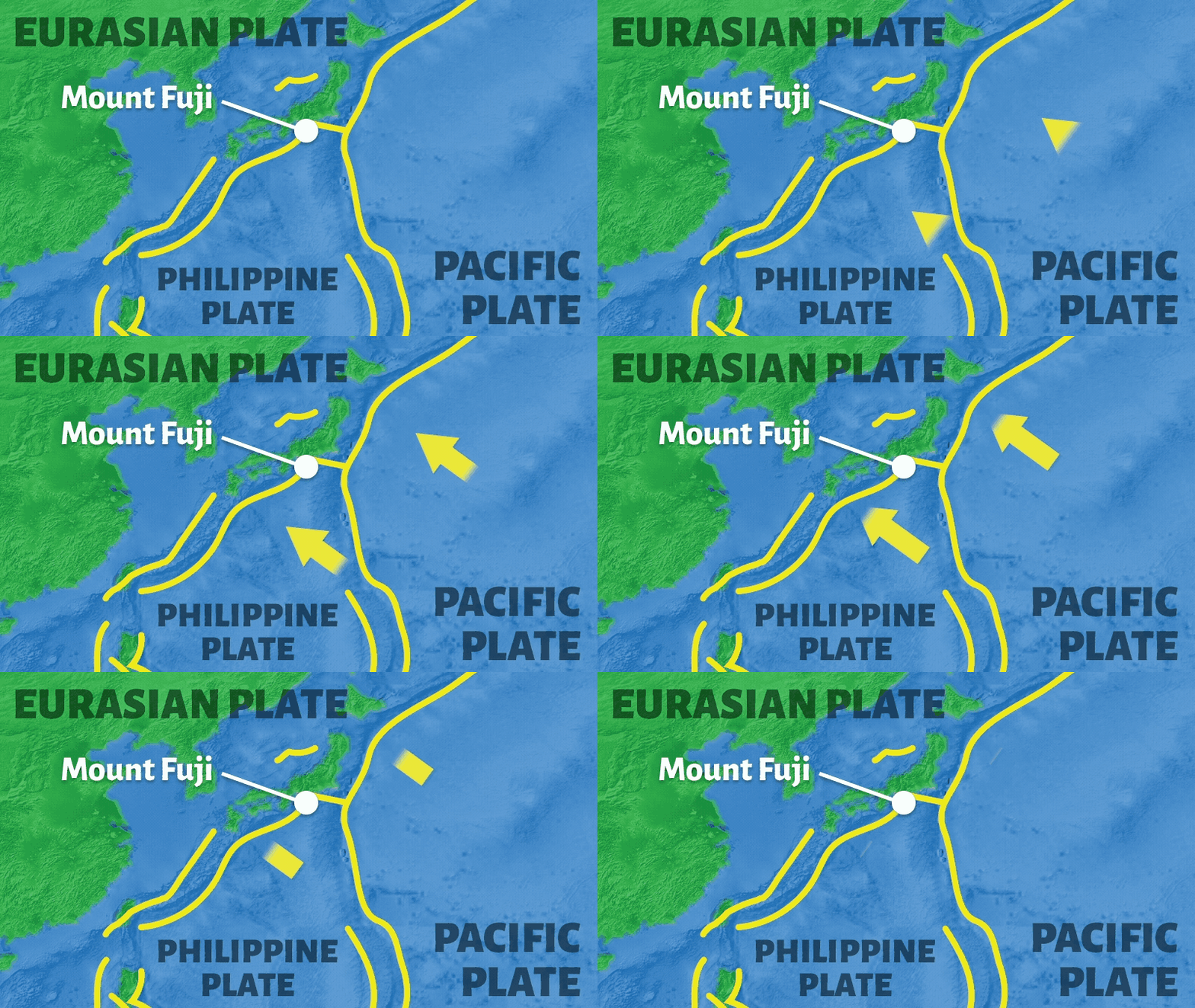
Which tectonic plate interaction caused Mount Fuji?

slip

collision

spreading

subduction
About Mount Fuji
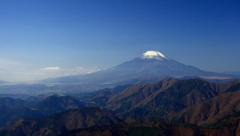
This volcano has been sleeping for centuries, but it could erupt again at any time. Mount Fuji lies just 97 kilometers (60 miles) from the city of Tokyo. It is Japan's tallest mountain. It is visible for hundreds of miles around!
Volcanic eruptions started forming this massive mountain about 11,000 years ago. The last explosion was 300 years ago. It formed a large, deep crater in the cone-shaped mountain. The explosion sent ash all the way to Tokyo. Today, steam rises from its peak and earthquakes occur within it. So scientists know that it could erupt again.
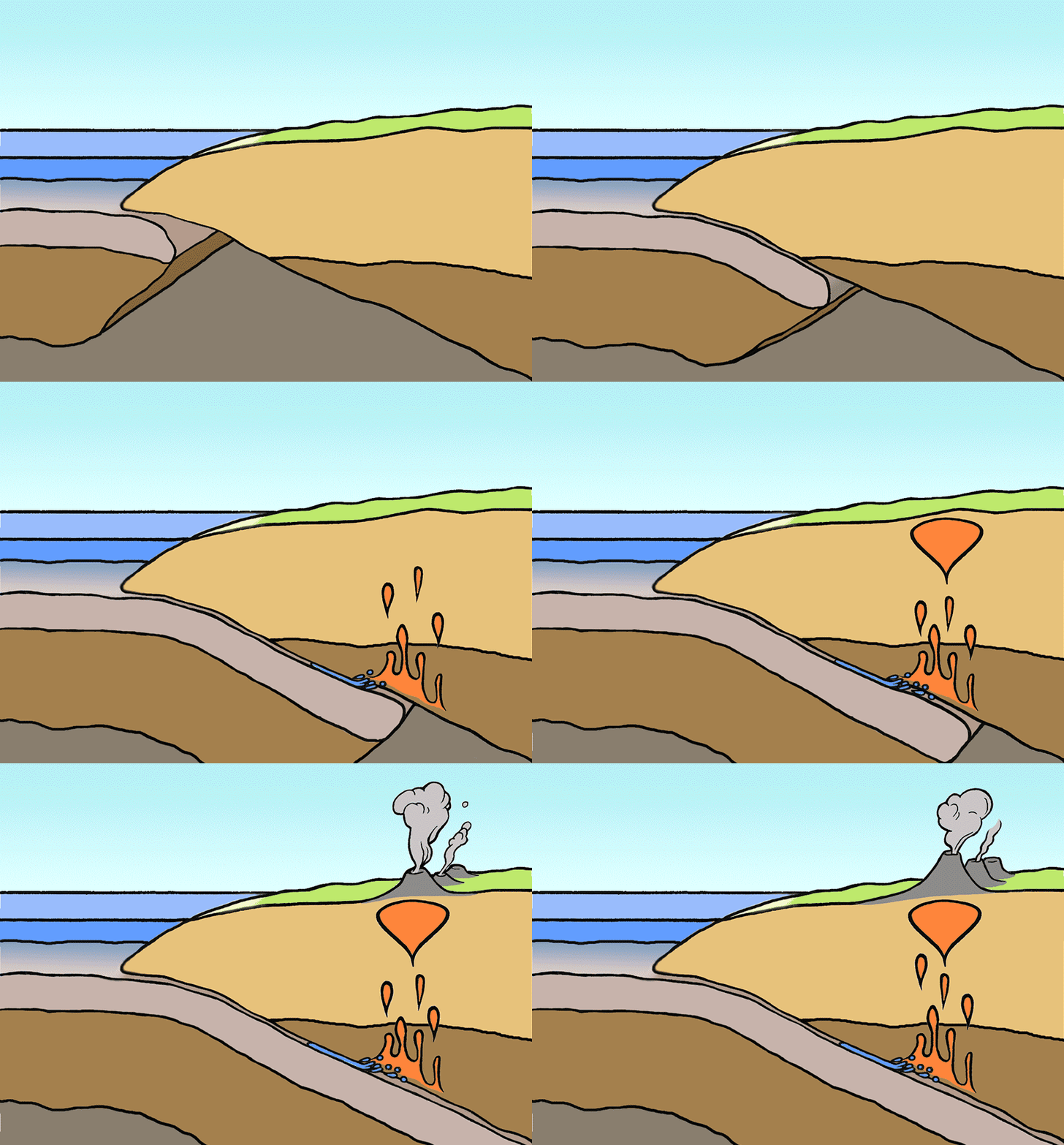
Mount Fuji is just one of 83 active volcanoes in Japan. In fact, the islands of Japan were formed by volcanic activity. They make up part of the Pacific Ring of Fire, chains of volcanoes that surround the Pacific Plate.
Japan also has more earthquakes than almost any other place in the world. Many of these earthquakes cause tsunamis. "Tsunami" is the Japanese word for giant tidal waves.
The Mount Fuji volcano remains active, but with no signs that it will erupt again soon.
STATS
Event: Volcanic eruption
Date: Last eruption was on December 16, 1707
Place: Honshu, Japan's main island
Size: 3,776 meters (over 2 miles) high; 50 kilometers (31 miles) across
Motion: Subduction of the Pacific and Philippine plates under the Eurasian Plate
Krakatau Eruption, 1883
INDONESIA
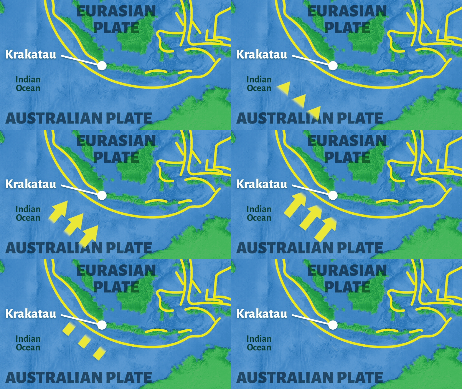
Which tectonic plate interaction caused the Krakatau volcanic eruption?

slip

collision

spreading

subduction
About Krakatau
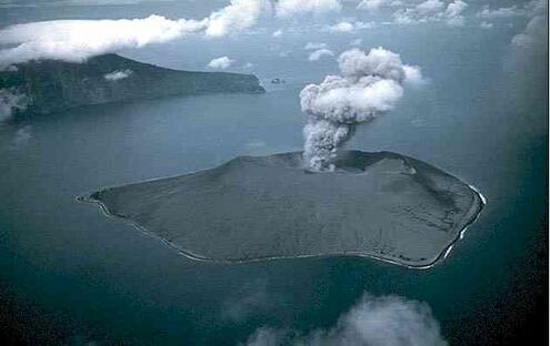
Imagine a volcanic eruption that could be felt across an ocean. This happened on Krakatau, a volcanic island of Indonesia.
The Krakatau volcano exploded over 100 years ago, yet it’s still one of the largest eruptions ever witnessed. It was so powerful it caused the volcano to collapse. The volcanic island was replaced by a deep underwater crater, or caldera.
The eruption set off devastating tsunamis, giant tidal waves that swept the coastlines of the Java and Sumatra Islands. The sound of the explosion was heard across the Indian Ocean. Magma was ejected as far as 40 kilometers (25 miles) away. The dust reached so high in the atmosphere that it created strange blue-green sunsets for months.
Krakatau was quiet for about 44 years. Then, starting in 1927 small eruptions began again. These small but frequent eruptions are slowly building a new island called Anak Krakatau (“child of Krakatau”).
STATS
Event: Volcanic eruption
Date: August 26-27, 1883
Place: Krakatau, an island of Indonesia (Southeast Asia)
Motion: Subduction of the Australia-India Plate under the Eurasian Plate
Mount Kilimanjaro
TANZANIA
Which tectonic plate interaction caused Mount Kilimanjaro?

slip

collision

spreading

subduction
About Mount Kilimanjaro
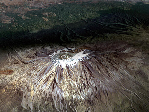
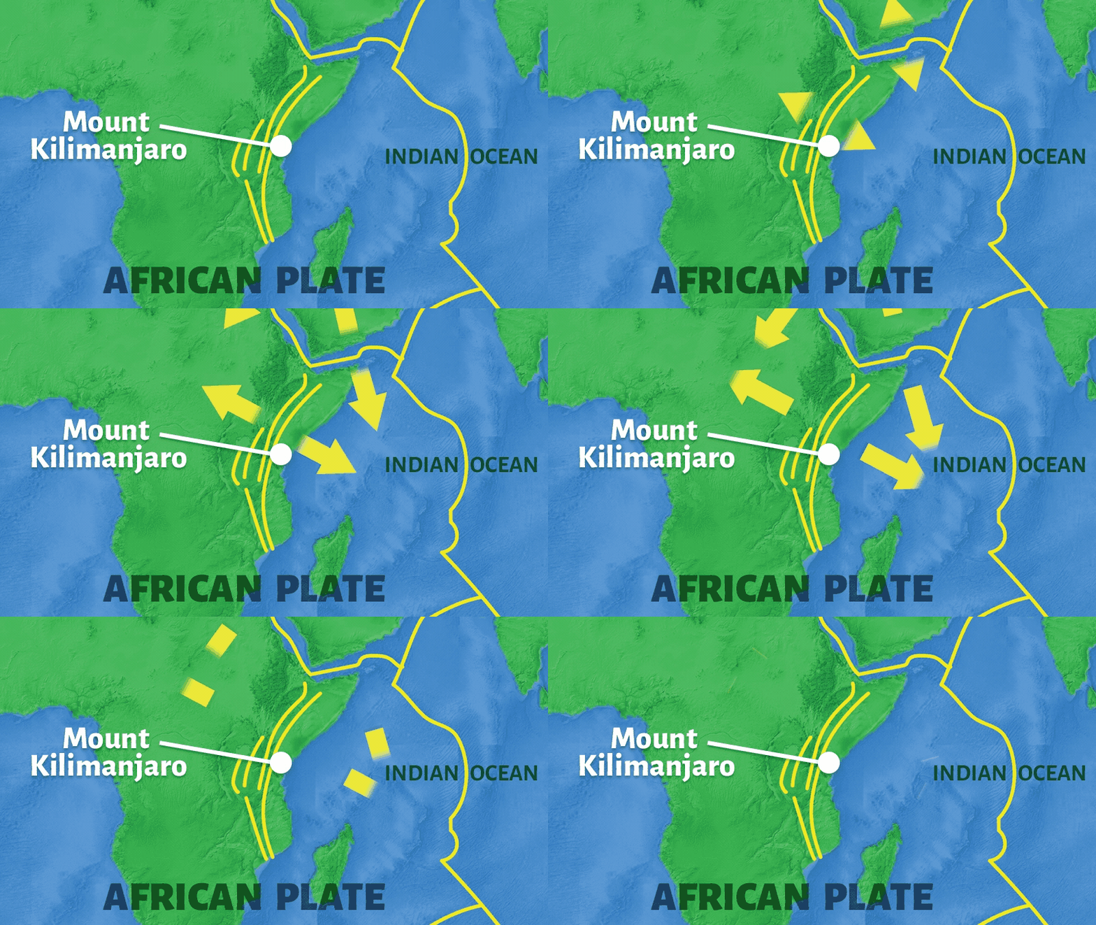
The tallest mountain in Africa is actually a sleeping volcano. Most volcanoes form where tectonic plates meet. But Mount Kilimanjaro, which is in Tanzania, began forming about 750,000 years ago in the middle of the African Plate.
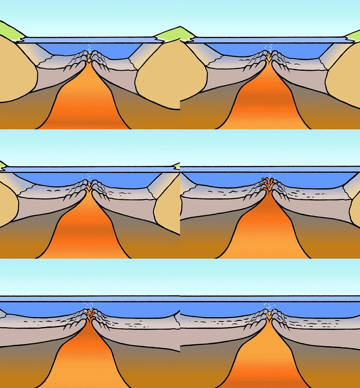
This is a very rare example of continental crust splitting. As the African Plate slowly separates, a deep crack or rift has been forming in Earth. Magma from Earth’s mantle rises and fills in the crack to form new crust.
These events formed a chain of volcanoes and the East African Rift Valley, a wide, green valley that stretches thousands of miles down the eastern part of Africa.
Mount Kilimanjaro last erupted about 100,000 years ago, but it is dormant. Because steam and sulfur gas are still emitted from its youngest cone, Kibo, scientists believe it may erupt again some day.
STATS
Event: Volcano formation in a rift valley
Date: Began forming 750,000 years ago
Place: Tanzania, eastern Africa
Size: 5,895 meters (19,340 feet) above sea level
Motion: Spreading of the African Plate
Izmit Earthquake, 1999
TURKEY
Which tectonic plate interaction caused the Izmit earthquake?

slip

collision

spreading

subduction
About the Izmit Earthquake
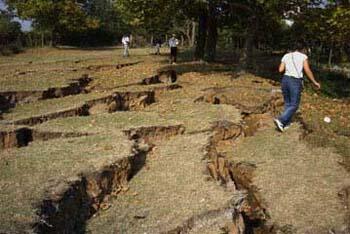
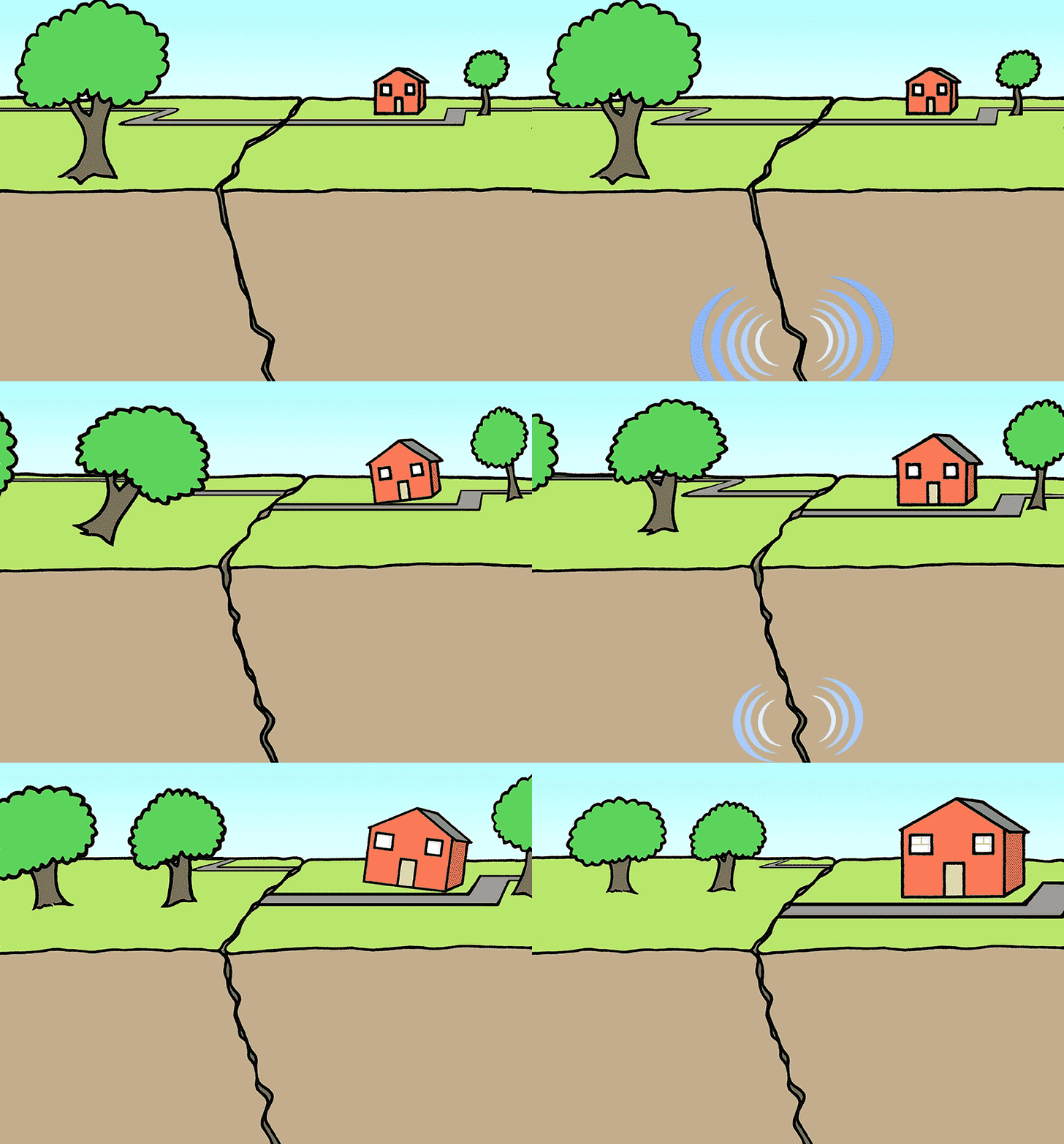
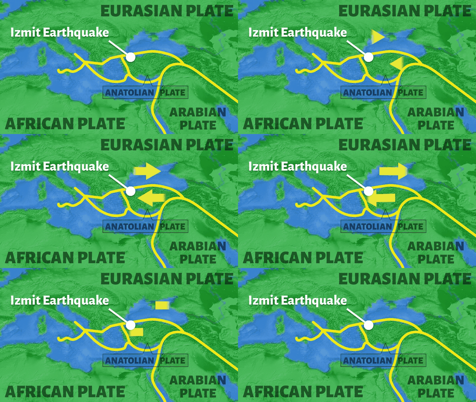
The small plate that holds Turkey is surrounded by frequent earthquakes. Most of Turkey lies on the Anatolian Plate. To the south, it is being squeezed by two larger plates. To the north, it is sliding against the Eurasian Plate at a speed of 2.4 centimeters (0.9 inches) per year.
A long fault line, called the North Anatolian Fault, stretches across the northern part of the country. Many powerful earthquakes occur along this fault.
One of the strongest earthquakes of the century occurred near the town of Izmit in 1999. Over many miles, fences, walls, roads, and rows of trees were offset, showing that the land had shifted as much as 5 meters (16 feet). The destruction was extensive and immense.
But while thousands of buildings collapsed, some of the oldest mosques remained standing. These mosques hold important clues for constructing buildings that can withstand future earthquakes.
STATS
Event: Earthquake
Date: August 17,1999
Place: Izmit, Turkey
Magnitude: 7.4 on the Richter Scale
Motion: West-directed slip of the North Anatolian Plate along the Eurasian Plate
The Island of Iceland
ICELAND
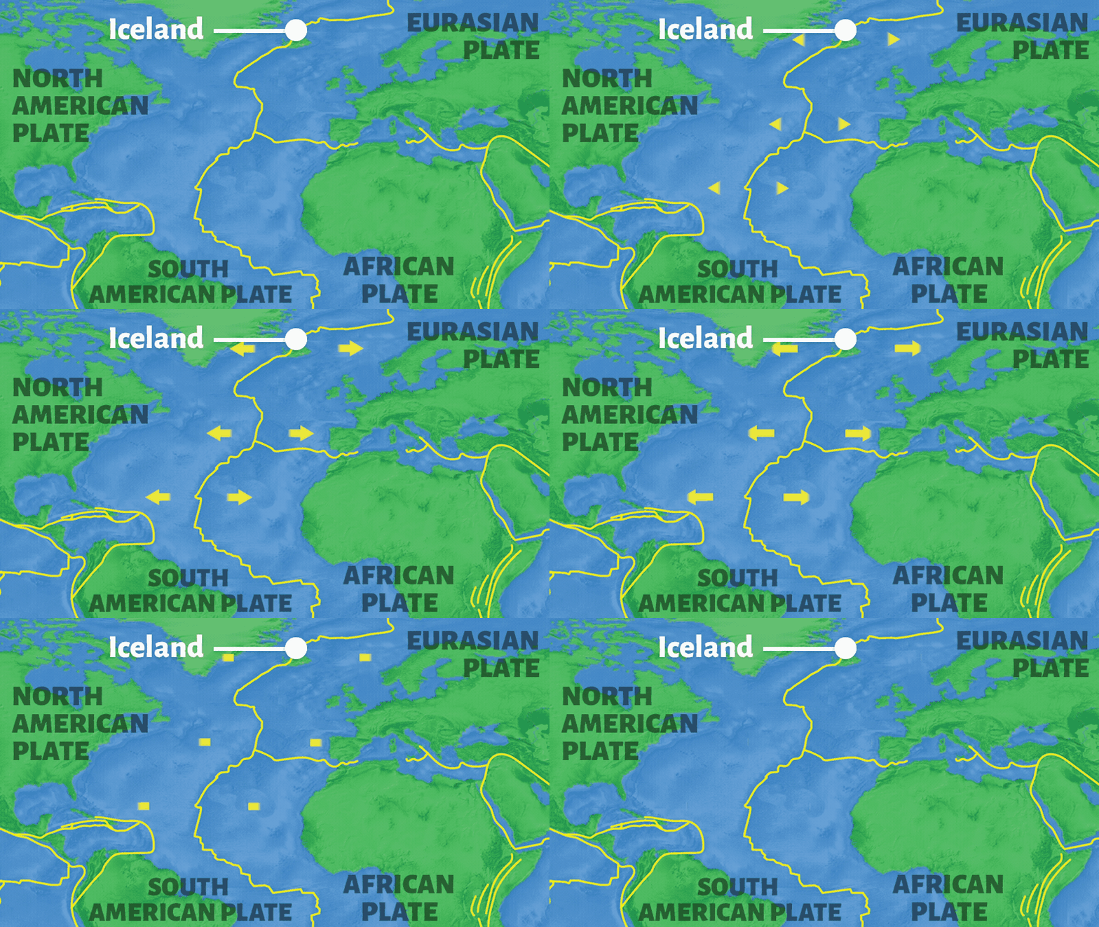
Which tectonic plate interaction caused the island of Iceland?

slip

collision

spreading

subduction
About Iceland
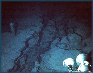
The island of Iceland was formed as a result of underwater volcanic eruptions along the Mid-Atlantic Ridge. The Mid-Atlantic Ridge is one of the longest volcanic chains in the world, but very few people have ever seen it. That’s because the Mid-Atlantic Ridge is deep underwater, stretching down the middle of the Atlantic Ocean.
Along the Mid-Atlantic Ridge, the plates are spreading apart. Between the spreading plates, magma rises up from Earth’s mantle to form volcanoes on the ocean floor. As the magma cools, it hardens to form new crust.
Although most of the Mid-Atlantic ridge is underwater, Iceland broke above the surface to become an island. This is because Iceland is also growing over a hot spot, an abnormally hot zone in Earth's mantle. The hot spot causes magma to rise up through Earth's crust and form volcanoes that continue to erupt today. The 2010 eruptions of the Eyjafjallajökull volcano caused the most significant disruptions in global air travel since World War II.
STATS
Event: Volcanic island formation
Date: Began to form about 55 million years ago; broke above the ocean surface 16-18 million years ago and is still forming today
Place: Iceland
Size: 64,002 square kilometers (39,769 square miles)
Motion: Spreading of the North American plate and Eurasian plates; hot spot beneath the island of Iceland
Mount Etna
ITALY
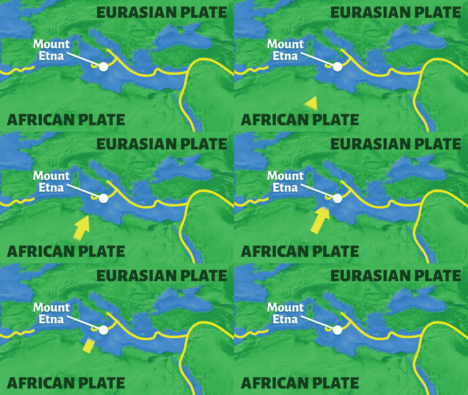
Which tectonic plate interaction caused Mount Etna?

slip

collision

spreading

subduction
About Mount Etna
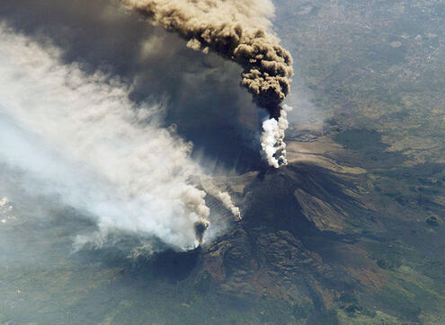
After 500,000 years, Mount Etna is still going strong. Italy is located in the boundary of two tectonic plates, so it has many active volcanoes. But Mount Etna is unique. It has been erupting more often and longer than most volcanoes in the world.
Mount Etna has erupted at least 190 times since its first recorded eruption, which was 3,500 years ago. But the volcano is actually much older than that. Layers of lava that are 500,000 years old have been discovered. In fact, these early eruptions were probably underwater!
Today, it still erupts frequently. Sometimes explosive eruptions send magma into the air like fireworks. Other times, lava flows down the mountain.
Scientists are monitoring Mount Etna closely, recording ash emissions and any earthquakes just below the surface. Based on this evidence, they predict that Mount Etna will continue to erupt.
STATS
Event: Volcanic eruption
Date: Currently active
Place: Sicily, Italy
Size: 3,310 meters (2,050 feet) high; 50 kilometers (31 miles) across
Motion: Subduction of the African Plate under the Eurasian Plate
Great Chilean Earthquake, 1960
CHILE
Which tectonic plate interaction caused the Great Chilean earthquake?

slip

collision

spreading

subduction
About the Great Chilean Earthquake
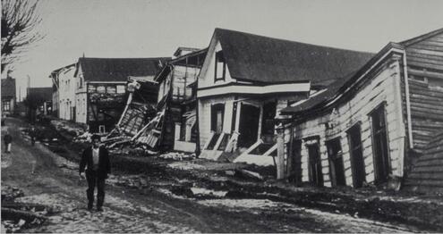
The largest earthquake on record sparked landslides, a volcanic eruption, and massive tsunamis.
One evening in May 1960, a few strong tremors shook towns along the coast of Chile. About 30 minutes later, the region was hit by the largest earthquake ever recorded. A massive rupture stretching hundreds of miles tore through Earth’s crust. An enormous tsunami swept over the Pacific Ocean.
About 18 hours later, the Puyehue volcano erupted, triggered by all the activity in Earth’s crust. Towns along the west coast of South America were devastated by enormous landslides and the sinking of land.
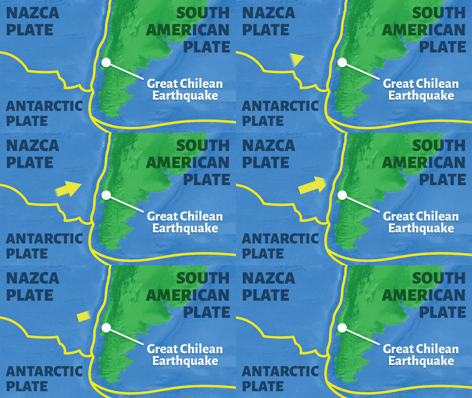
This incredible destruction was caused by the Nazca Plate moving under the South American Plate. When the plates get jammed, they squeeze together and pressure builds up. Earthquakes occur along this boundary when the stress between the plates is finally released.
The movement of these plates has also formed the Andes, the tallest chain of volcanic mountains.
STATS
Event: Earthquake
Date: May 22, 1960
Place: Chile, South America
Magnitude: 9.5 on the Richter Scale
Motion: Subduction of the Nazca Plate under the South American Plate
Mount Saint Helens Eruption, 1980
UNITED STATES OF AMERICA
Which tectonic plate interaction caused the Mount Saint Helens eruption?

slip

collision

spreading

subduction
About Mount Saint Helens
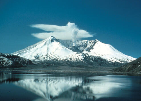
At 8:30 one Sunday morning, an earthquake shook the Mount Saint Helens volcano. It was not unusual: small earthquakes had been trembling in the area for a couple of months. But this earthquake sparked a large landslide on the steep side of the volcano. Suddenly, the magma held deep inside the volcano was released. Hot gas, ash, and rocks exploded out of the volcano. Trees were flattened. Homes were destroyed.
The worst of the eruption lasted just 10 minutes. When it was over, the volcano’s peak had been replaced by a mile-wide, horseshoe-shaped crater.
The violent eruption was not a surprise. Scientists had noticed rising steam and small eruptions of ash. They also observed a growing bulge on the side of the volcano, caused by rising magma.
Mount Saint Helens is one of 15 volcanoes that form the Cascade Mountain Range along the West Coast of the U.S. The Cascades are a part of the Ring of Fire, a large circle of explosive volcanoes around the Pacific Ocean.
This volcano remains active, but with no signs that it will erupt again soon.
STATS
Event: Volcanic eruption
Date: May 18, 1980
Place: Washington State, U.S.; Cascade Mountain Range
Size: 2,950 meters (9,670 feet) before the 1980 eruption; 2,550 meters (8,360 feet) after the eruption
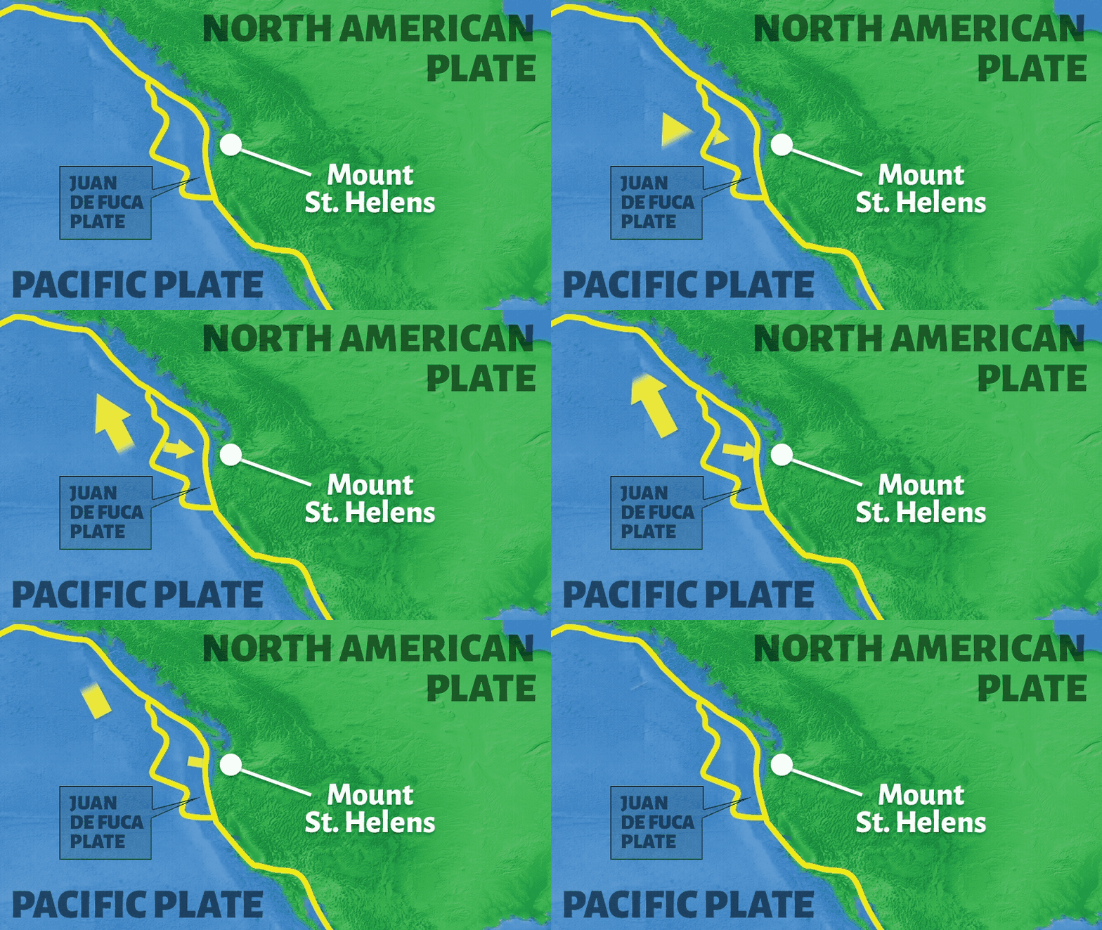
Motion: Subduction (Juan de Fuca plate under the North American plate)
San Francisco Earthquake, 1906
UNITED STATES OF AMERICA
Which tectonic plate interaction caused the San Francisco earthquake?

slip

collision

spreading

subduction
About the San Francisco Earthquake
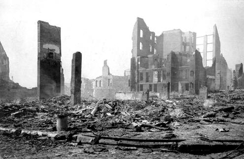
One early morning more than 100 years ago, the residents of San Francisco were awakened by a strong tremor. The powerful shaking lasted almost a minute, causing many of the city’s buildings to collapse. Broken gas pipes set off fires that destroyed most of the city.
When it was all over, scientists were amazed to find huge cracks in the ground many miles long. This was one of the strongest earthquakes ever recorded in North America.
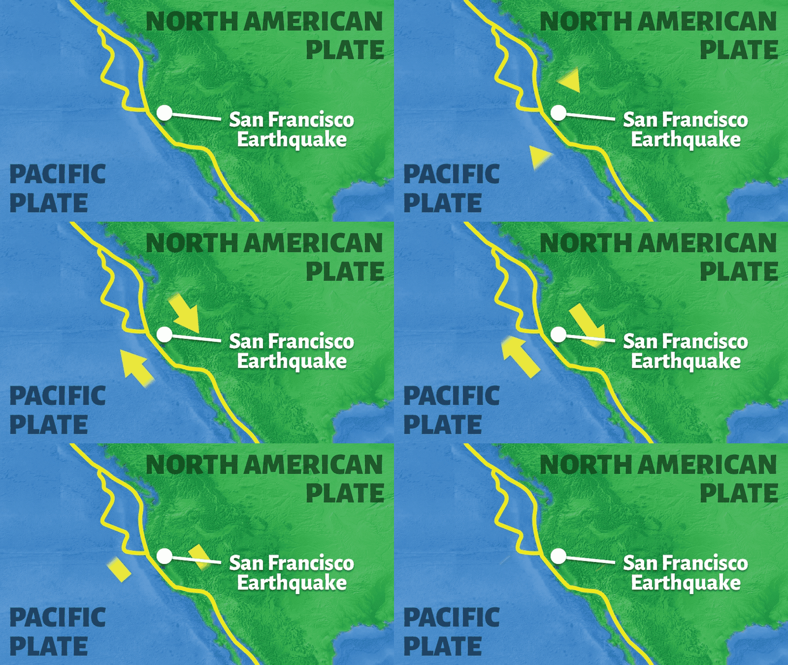
California has tens of thousands of earthquakes every year because it lies at the boundary of two tectonic plates. These two plates are slowly sliding past each other at a speed of about 5 centimeters (2 inches) every year.
This movement has formed the San Andreas Fault, a zone of deep cracks in Earth’s crust that extends from northern to southern California. Almost all the earthquakes in California occur along the San Andreas Fault.
STATS
Event: Earthquake
Date: April 18, 1906
Place: San Francisco, California, U.S.A.
Magnitude: 7.9 on the Richter Scale
Motion: Northwest-directed slip of the Pacific Plate against the North American Plate
The Hawaiian Islands
UNITED STATES OF AMERICA
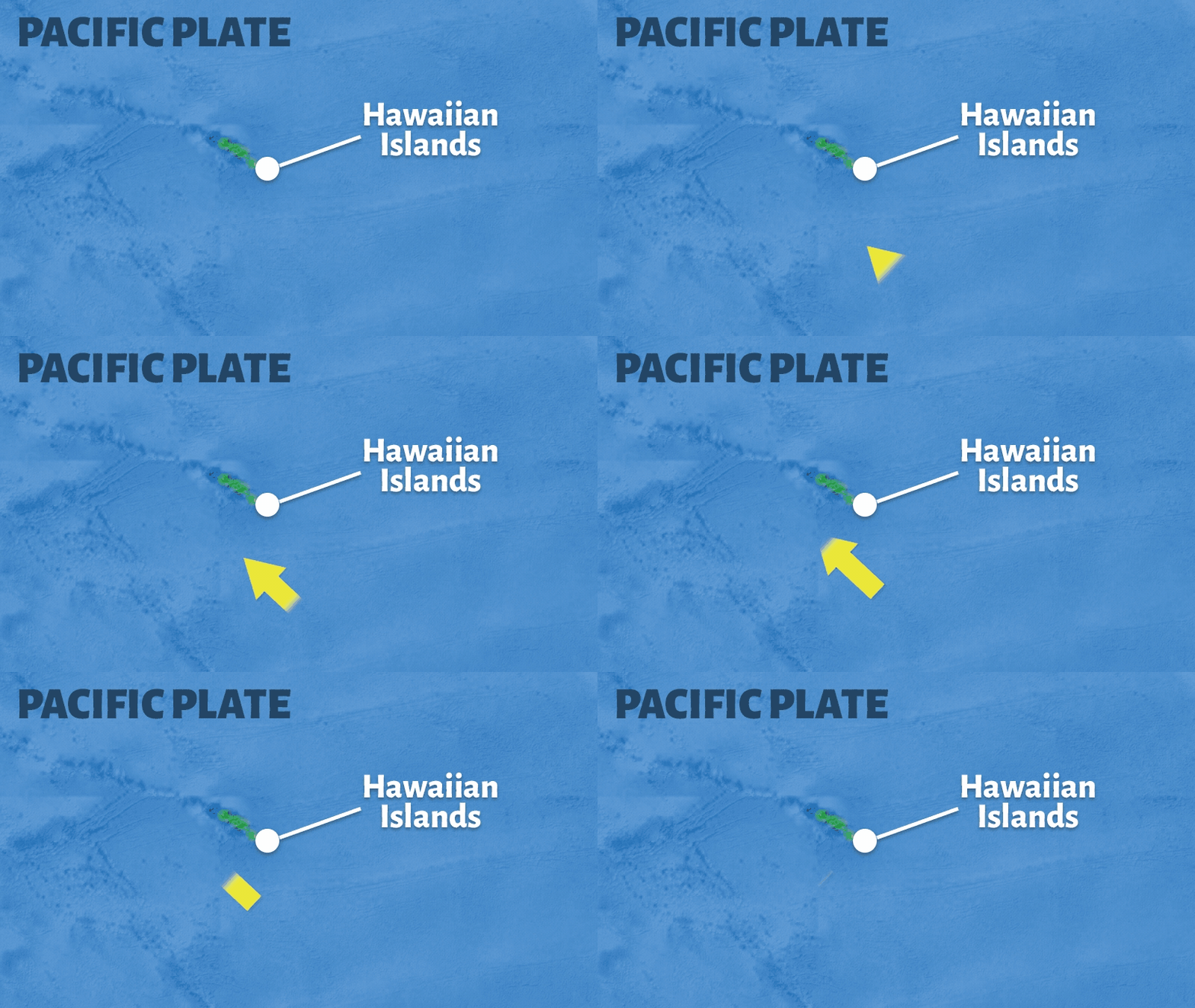
The movement of a tectonic plate over a hotspot caused the Hawaiian Islands!
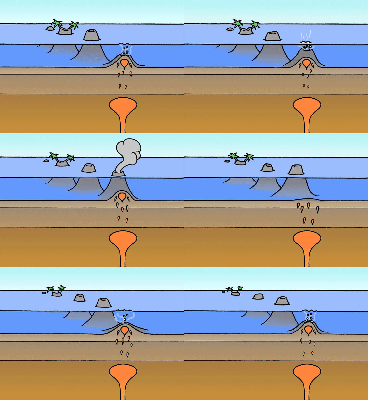
A hot spot is an intensely hot area in the mantle. Magma rises from the hot spot, forming a volcano at Earth's surface. As the tectonic plate moves over the hot spot, new volcanoes form.
About the Hawaiian Islands
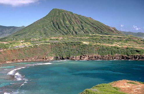
Someday, Hawaii will have new islands, and the older ones will disappear into the sea.
The Hawaiian Islands are actually volcanoes. Most volcanoes form at the edges of tectonic plates. But the Hawaiian Islands are growing over a hot spot, an extremely hot zone in Earth’s mantle. The hot spot causes magma to rise up through Earth’s crust and form a volcano. As the volcanoes grow, they break above the surface of the ocean and become islands.
The hot spot under Hawaii has pretty much stayed in the same place. As the plate above it moves, the volcanic islands are carried away and new ones form over the hot spot. Over time, the older volcanoes are worn down by wind and water until their peaks sink below the sea.
Currently, the Big Island of Hawaii is over the hot spot. It is the youngest island and made of five volcanoes. But this island is slowly moving away, and a new volcano, Loihi, is already forming underwater. It is just a volcanic baby now, but in only 250,000 years, it, too, will rise above the ocean.
STATS
Event: Volcano and island formation
Date: The Hawaiian Islands began forming 5.5 million years ago
Place: Middle of the Pacific Ocean
Size: The tallest volcano is 17 kilometers (11 miles) high
Motion: Hot spot under the Pacific Plate
1964 Alaska Earthquake
ALASKA, U.S.A.
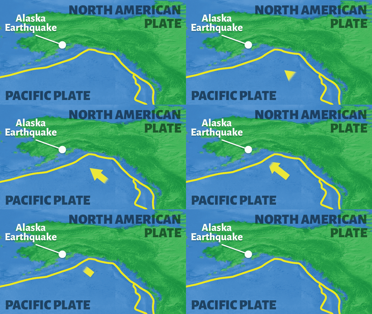
Which tectonic plate interaction caused the Alaska earthquake?

slip

collision

spreading

subduction
About the Alaska Earthquake
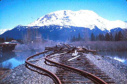
The destruction from this earthquake was enormous. Hundreds of miles away, in the town of Anchorage, buildings were destroyed by landslides and avalanches. In some places, part of the ground sunk below sea level.
The earthquake also triggered a tidal wave, or tsunami, that swept towns along the coast of Alaska, Canada, and Washington State. Hours later, the tsunami wave reached Hawaii and then South America.
This earthquake was caused by the slow steady push of the Pacific Plate under the North American Plate. This motion is squeezing the crust of southern Alaska, building up pressure. Every now and then, the pressure is released, and the North American Plate suddenly snaps back over the Pacific Plate. This causes an earthquake.
The constant movement and intense strain between these plates cause major earthquakes in Alaska almost every year. In fact, Alaska has more earthquakes than any other state in the U.S.
STATS
Event: Earthquake
Date: March 27, 1964
Place: Prince William Sound, Alaska, U.S.A.
Magnitude: 9.2 on the Richter Scale
Motion: Subduction of the Pacific Plate under the North American Plate

= plate boundary
Image Credits:
Earth map, courtesy of NOAA; mountain icon, created by Alice Noir from the Noun Project; Alaska earthquake, courtesy of USGS; Mount St. Helens, courtesy of U.S. Department of Interior; San Francisco earthquake, courtesy of USGS; Hawaii, courtesy of NASA; Mid-Atlantic Ridge, courtesy of Woods Hole Oceanographic Institution; Chile earthquake, courtesy of USGS; Mount Etna, courtesy of NASA; Turkey earthquake, courtesy of USGS; Mount Kilimanjaro, courtesy of NASA; Himalayas mountains, courtesy of NASA; Krakatau volcano, courtesy of R.W. Decker, http://www.doubledeckerpress.com; Mount Fuji, courtesy of NASA and AMSR-E


 Biodiversity
 Brain
Brain
 Genetics
 Marine BiOLogy
 MicrobiOLogy
 PaleontOLogy
 ZoOLogy
 AnthropOLogy
 ArchaeOLogy
 Astronomy
 Climate Change
 Earth
Earth
 Physics
 Water
Water

