Volcanoes, From Field to Lab
Courtesy of gallica.bnf.fr/Bibliothequé nationale de France
The 19th-century writer Lafcadio Hearn compared the Caribbean city of Saint-Pierre, Martinique, to "the sensation of some happy dream." Cafes and shops lined its bustling cobbled streets, and residents strolled in its parks and botanical gardens. Looming over it all, as Hearn described it, was "the verdant violet-shaded mass of the dead Volcano," Mt. Pelée. But soon after the turn of the 20th century, Martinique’s happy dream would turn into a grim nightmare.
Like its neighboring islands, Martinique formed at the boundary of two tectonic plates gliding across Earth’s surface about 24-30 million years ago. As one slid beneath the other, melting occurred and helped forge islands, mountains, and volcanoes, including Mt. Pelée.
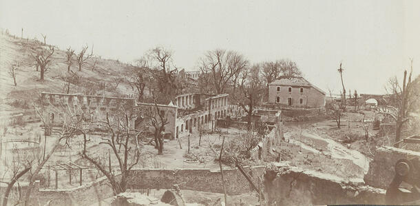
In spring 1902, Mt. Pelée began waking up. First, a small eruption. Then, intensifying signs of subterranean rumbling: groundwater disturbances, mudslides, volcanic ash at the summit. On May 7, a warning: Mt. Soufrière erupted on the neighboring island of St. Vincent, killing more than 1,500 people. On May 8 came Mt. Pelée’s turn. A blast of hot gas, ash, and rocks raced down the volcano’s slopes at 300 miles per hour, obliterating Saint-Pierre, which lay just 4 miles away, and claiming more than 27,000 lives in a single afternoon.
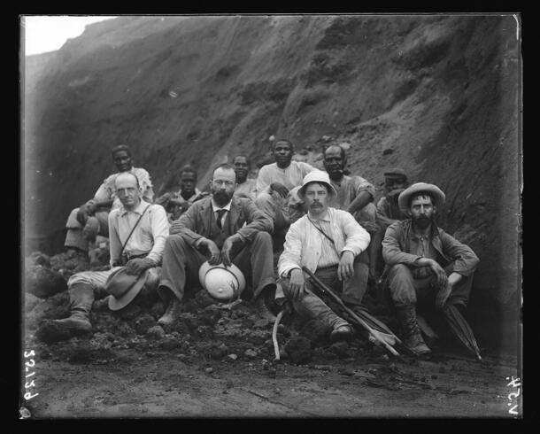
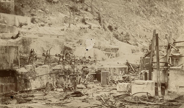
When news of the twin catastrophes reached New York, Museum geologist Edmund Hovey managed to book passage for himself and a small team on the U.S. cruiser Dixie, which was leaving New York on a relief mission to provide supplies, food, and aid to survivors of the devastation.
The scale of the destruction wasn’t lost on Hovey, who wrote that “nothing has occurred within a century which has so stirred the civilized world as has the annihilation of the beautiful city of Saint-Pierre.” His haunting photographs show an island “laid waste by dust, lapilli, stones, and ‘mud.’” But Hovey and his team also hoped that by visiting the area in the immediate wake of this tremendous eruption, they could unearth secrets behind volcanic explosions only available to researchers after a world-shaking event.
Volcanoes play tricks with human timelines. Mt. Pelée, which sat quietly for decades leading up to its lethal 1902 explosion, was long thought by Saint-Pierre’s citizens to be extinct. Like Italy’s Mt. Vesuvius, which buried the cities of Pompeii and Herculaneum thousands of years ago, the risk never registered with residents who hadn’t witnessed a big eruption in several generations.
“Vesuvius has these huge catastrophic eruptions that are separated by periods of 500 to several thousand years,” says James Webster, a curator in the Museum’s Department of Earth and Planetary Sciences who studies cycles that underlie volcanic eruptions, including Vesuvius’s. “[Today,] it’s a heavily populated area. Probably 600,000 [people] live within what’s called the Red Zone, the danger zone in the vicinity of Mt. Vesuvius.”
The violent eruptions of Mt. Pelée and Mt. Vesuvius are what most of us think of when we imagine an active volcano—molten rock and magma being violently launched from the heart of a mountain, accompanied by flowing lava and columns of smoke-like ash and cinder rising to the sky.
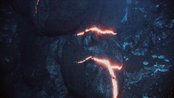
But these dramatic eruptions are actually rarities in terms of volcanic activity. The vast majority of magma escapes onto the surface of the Earth with little fanfare, oozing slowly onto the surface of the planet, often at the seafloor at a thickness and speed not unlike toothpaste being squeezed from the tube.
What a volcanic eruption looks like is largely determined by the composition and properties of its magma. In the case of Mt. Pelée, the magma being discharged had a high silica content, making it thick and viscous. It also had a high gas content, meaning that thick material was filled with millions of tiny, energetic gas bubbles. When this thick, gassy magma escapes a volcano, it does so violently.
Alongside clouds of cinder and plumes of ash, magma with high gas and high silica content from what are called stratovolcanoes form a signature artifact: the bread-crust bomb. Bread-crust bombs are named for their cracked and broken outer surface, which recalls cracks and crannies found on the outside of a bread loaf. These rocks are formed as lumps of magma ejected from a stratovolcano eruption cool and solidify in the air at the Earth’s surface. As they cool, the surface of the rock contracts which cracks and shatters the brittle surface of the new stone on their escape. Some bread-crust bombs are lined with bubbles—the tiny tracks of gas that followed the spectacular release during their birth.
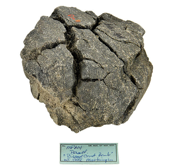
Following the massive eruption of Mount Pelée, Hovey reported encountering bread-crust bombs “of all sizes, from 1 inch to 3 feet and more across.” During the eruption, even the largest of these stones was thrown into the sky with overwhelming force. Hovey noted that a Saint-Pierre distillery’s tanks looked “as if they had been through a bombardment by artillery”—their iron plates blasted through with holes measuring several feet wide.
Whereas Hovey could only rush to the scene post-eruption to collect accounts and specimens, today’s geologists can bring volcanic processes to a more convenient location. In his lab at the Museum, Webster and his colleagues simulate the forces at work inside the Earth to learn how they shape magma.
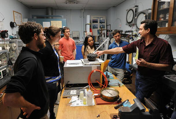
By exposing different combinations of molten rocks and gases to varying temperatures and pressures, the Museum’s experimental petrology team works to understand how explosive magmas release gases. They can then compare their lab results to the composition of specimens collected in the field—all to better understand the conditions leading up to a volcanic eruption.
“It’s steps away from actually predicting eruptive behavior,” Webster cautions. But one day, studies like Webster’s could help to give communities near volcanic hotspots a better idea of what the lead-up to an eruption looks like, providing valuable warnings ahead of disastrous events.