Plate Tectonics Puzzle
Part of the Dinosaurs: Activities and Lesson Plans Curriculum Collection.
The Earth’s crust is not a solid shell.
It is made up of thick, interconnecting pieces called tectonic plates that fit together like a puzzle.
Tectonic plates move atop the underlying mantle, a really thick layer of hot flowing rock. By examining evidence such as similar rock layers in various places, fossilized desert belts, the distribution of fossils, and the physical shapes of continents, scientists have concluded that the Earth’s continents were once all connected to form a “supercontinent” called Pangaea that was surrounded by an enormous ocean. In this activity, students will use the different kinds of evidence to reconstruct how the Earth may have looked approximately 220 million years ago.
Objectives
Students will:
- use logic and the evidence to reconstruct the position of large islands and continents as they appeared 220 million years ago.
- understand the theory of continental movement and plate tectonics.
- describe how scientists use different kinds of evidence to form theories.
Time Frame
Two class periods (40 minutes each)
Materials
- Globe or world map
- Answer page Per pair of students:
- Reproducibles of instructions and continent cutouts pages
- Scissors
- Glue or tape
- Sheet of paper
- Ruler or compass
Procedure
Prior Knowledge
1. Introduce students to the concept of continental movement and plate tectonics. Call on volunteers to tell what they know about plate tectonics. Display a globe or world map. Have students look carefully at the continents. Discuss with them how Europe, Africa, South America, and North America might fit together as puzzle pieces. Discuss what might explain this fit. Point out that millions of years ago the continents were joined together in one supercontinent called Pangaea. Using some of the same evidence that scientists use, they will reconstruct this supercontinent.
Exploration
2. Have students work in pairs. Distribute the materials to each pair. Provide time for them to review the instructions page.
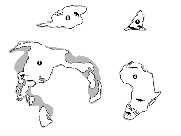
3. Explain that the landmasses they will be cutting out represent the continents and some of the larger islands of the Earth the way scientists think they appeared 220 million years ago. On a separate sheet of paper, have students draw a large circle, about 8 inches in diameter, to represent the globe. Then have them cut them out the islands and continents. Using the legend on the instructions page, call on volunteers to identify what each symbol stands for.
4. Tell students they are going to use the evidence (symbols) on the continents and islands to reconstruct Pangaea, the supercontinent. Using the globe or world map as a reference, discuss with students in what general area the continents should be positioned. Ask them to identify what they should look for to determine which continental boundaries should be joined.
5. Using the physical shape of continents, age of rock layers, fossilized desert belts, and the distribution of fossils, have partners fit together the continents and islands. Remind them that not all the boundaries may touch and that there might be areas of water separating some of them. Once students are sure the landmasses are in the correct position, have them tape or glue them onto the world map. Have them label their maps along with the time period.
Wrap-up
6. When students have completed the activity, have them compare their world maps. Call on pairs to discuss how they reconstructed the supercontinent and what evidence led to their decisions. Call on volunteers to identify the continents and islands.
7. Display the answer page and have students compare it to their completed Pangaea maps.
Extension
Students can further explore plate tectonics by visiting Plates on the Move (ology.amnh.org/earth/plates) on OLogy, the Museum’s website for kids. This interactive feature examines the huge impact that plate tectonics has on the Earth, including the formation of oceans, continents, and mountains, and the occurrence of events such as earthquakes and volcanic eruptions.