Shaped by Nature and Man: The Geological History of the Palisades
Part of the Young Naturalist Awards Curriculum Collection.
I stand at the very edge of the cliff, looking out across a vast horizon. My eyes trace the ancient sill of lava curving around the land like a gigantic fortress. Glancing down, I can see the jagged wall of rock plunging straight down 400 feet to the Hudson River. I am fascinated by the thought that continental plates once collided and then pulled apart and huge glaciers swept across the very spot on which I stand. Since my childhood, the high point of this sill has loomed directly across the Hudson River from my town, mysterious and majestic. I have often wondered how a rock formation that is so enormous and has cliffs that are so vertical could have come to exist. Now I stand on the very top of the Palisades, and my expedition is about to begin.
After taking a short field trip last year with my earth science class to local sites of geological interest, I became very interested in the Newark Lowlands area and, specifically, the Palisades. I wanted to know more, and so I began doing some research at the library and on the Internet. I was so intrigued by what I learned that I decided to take a more in-depth expedition to some of the sites I had previously visited with my earth science class.
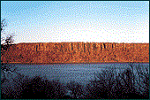
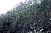
When I got to Rockland State Park on the day of my expedition, it was cloudy and snow was predicted for later in the afternoon. I decided to try to get to the top of the Palisades sill right away. I knew that I would be able to get a great overview of the whole Newark Lowlands area from there. I stepped off the path and headed for the woods. I soon found a small, winding path and headed up the towering backside of the cliff. Finally, I reached the top. Looking across the vast land, I could see the long sill curving away and the rock quarry off in the distance (Figure 1).
According to the theory of plate tectonics, almost all the modern continents were once joined together into one supercontinent called Pangaea. This great landmass began to rift apart around 200 million years ago. Huge amounts of underground molten rock (known as magma) shot upward through giant cracks in the earth. Some of it erupted above ground as lava, but much of it was trapped underground between sedimentary layers.
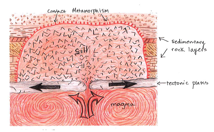
When the trapped magma first intruded into the Triassic layers of sedimentary rock, it was so hot that contact metamorphism occurred, altering the rock around it (as illustrated in Figure 2). In the case of the Palisades, the magma cooled under the sedimentary layers, forming a sill made of igneous diabase about 40 miles long and 1,000 feet thick. During this time, crustal movements along the Ramapo fault tilted the entire region downward about 17 degrees to the west. (Serrao, p. 4).
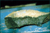
The igneous diabase of the Palisades is composed almost entirely of roughly equal amounts of dark pyroxene and lighter plagioclase feldspar. Because the solidification process was slowed down during the underground cooling of the magma (in this case taking thousands of years), the crystals had more time to grow and become bigger and more coarsegrained (Figure 3).
As the magma cooled and solidified underground, it contracted and great pressure built up. This tensional stress was relieved by vertical cracks several hundred feet long. These cracks formed the sill into polygonal columns (Figure 4). This appearance, which made the columns look like the stockades used by Native Americans to protect their villages, gave the Palisades their name.
Glaciers have also affected the surface features of the Palisades sill. A glacier forms when large amounts of snow fall in the same place time and time again. After a long time, the weight of the accumulated snow compresses the snow at the bottom into ice, which grows thicker as snow continues to fall and exert pressure. Functioning as a liquid, the ice on the bottom causes the glacier to slowly slide in whichever direction it can most easily move. During the last Ice Age, thousands of feet of ice covered the Northern Hemisphere. When the last glacier in this region began to retreat, about 12,000 to 15,000 years ago, it had many effects on the Palisades.
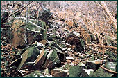
At that time, the Palisade sill did not look the way it looks today. A large accumulation of talus (rock pieces chipped off the sill) was piled up against the side of the sill, along with soil and vegetation, creating a sloping hillside down to the river (Figure 5). When the glacier passed through, all the loose sediments, rocks, plants, and wildlife were swept away, leaving stark vertical cliffs. In addition, the bedrock was polished and smoothed by the weight of the ice. Friction between the rocks the glacier was carrying and the diabase gouged out marks in the sill called chatter marks.
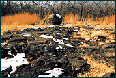
Figure 6 shows glacial polish, right-angle fracturing in the foreground, and a glacial boulder in the background. When a glacier moves over a large rock, it grinds against the surface, and makes it smooth. A glacier can also pick up smaller rocks and carry them. While the rocks are being carried by the glacier, they are being banged against each other and ground under the tremendous weight of the ice. This grinds down the edges and smoothes the rocks' surface. When a glacier carries a rock from somewhere far away and leaves it somewhere else, it is called a glacial erratic.
Glacial erratics and glacial boulders are usually easy to spot because of their shape. I was able to recognize the large round rock as a glacial boulder because of its smooth and rounded shape. Further geologic examination of the boulder might show if the rock had been carried a great distance by the glacier. I was also able to easily identify that the rocks in the photograph had been polished by a glacier because of their smoothed surface.
I could clearly see intersecting straight lines crisscrossing the surface of the rock. These right-angle fractures are present throughout the entire Palisades sill and are due to columnar jointing, which occurred while the magma was cooling. During this time, contractional fissures and tensional cooling formed vertical cracks in the rock. Also, when the glaciers moved on, rebound occurred. The release of the stress of the glaciers' extreme weight caused long vertical cracks, or "joints," to form in the sill, breaking it up into polygonal columns several feet wide.
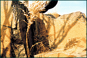
In addition to columnar jointing, the sill has been affected by physical and chemical weathering. Looking over the edge of the cliff and down the 400-foot precipice, I noticed that an almost perfectly square chunk of rock was missing from the top of one of the nearest columns, right beneath the foot shown at the top edge of the photo (Figure 7). This is evidence of physical weathering following and amplifying the effects of jointing. Columnar jointing originally outlined the initial cracks of the missing block. Ice wedging did the rest. This process occurs when water falls into a crack in the rock and freezes. The frozen water then expands, exerting a huge amount of pressure on the rock on either side of it. This pressure can be as much as 2,000 pounds per square inch (Palisades Interstate Park Commission, "Timelines") and results in either a widening of the crack or the knocking off of a chunk, which then tumbles as talus down the cliffside.
The sill has also been weathered chemically. This can be seen in the orange color of the rock where the block used to be. When the chunk was first removed, the remaining rock would have been gray. However, with the passage of time and exposure to water and oxygen, the high iron content of the rock has caused it to rust.
When the magma first intruded through the Triassic layers of sedimentary rock, it was so hot that it metamorphosed the rock around it. The shales were changed to hornfels, while the sandstones, less affected, changed to hard quartzites. The place where this occurred is called a contact zone.
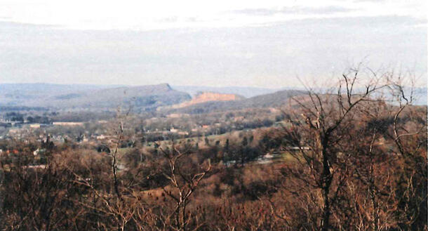
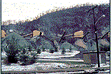
I tried to find a contact zone. I had heard about a trail somewhere near the Tilcon Quarry in Haverstraw, NY, that led to a red sand beach where supposedly there was a contact zone. I searched for several hours in the woods and along the beach, but I was unable to find it. However, the search did reveal the bigger picture. I was able to see where the igneous sill rose up and intruded through the sedimentary layers.
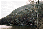
Figure 8 illustrates the horizontal layers of sediment rising up from the Hudson River, with the vertical igneous sill coming through at the top. The hot rock of the sill originally cooled under many layers of sedimentary rocks. Over millions of years, these layers eroded away, because sedimentary rock is much softer and therefore less resistant to weathering and erosion than igneous rock. Now there are only remnants of the sedimentary rock, with the hard diabase sill towering above.
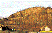
Adjacent to Rockland State Park is the Tilcon Quarry, where I stopped to see what was currently being done with the diabase from the sill (Figures 9 11). Upon arriving at the quarry, I immediately noticed gigantic piles of different-sized rocks. Each pile was composed of rocks of a larger size than the one before. Continuing around the quarry, I could see the conveyor belts running through machines that break the rocks into the smaller pieces, which were then sorted by size and made into the piles I had seen earlier.
The Palisades is not only rich in geological history, but in economic history as well. During the 19th century, the durable diabase was used for constructing buildings. Many of the early homes in the area, including many of New Jersey's historic Dutch farmhouses, were built from the red sandstones, as were the brownstones of New York City. Right after the Civil War, large amounts of rock were shipped to New York and other cities to become "Belgian" paving blocks. Most of these rocks were gathered from the talus slopes at the bottom of the sill.
In the late 1800s, when the streets of New York City were being paved on a large scale, there was an even greater attack on the Palisades. Because of the tremendous value of the ancient rock, the Palisades were in great danger. In Rockland County there were 31 quarries between Grandview and Upper Nyack. One firm alone was taking 12,000 cubic yards of traprock a day (Roseberry, p. 253). Today the rock is mostly used for large blocks in the construction of sea walls and as crushed gravel for concrete and pavement.
One mile north of Fort Lee, N.J., the Palisades formed two different profiles. One was called Indian Head and the other Washington Head. In September 1897, men from the quarries blew up Washington Head. Then in March 1898, a five-foot hole was bored a hundred feet into Indian Head and 7,000 pounds of dynamite were placed inside. Indian Head was blown up, leaving 350,000 tons of Palisade diabase intended for construction (Roseberry, p. 254).
Eventually, people began to notice the desecration of the Palisades and in 1900 the Interstate Park Commission was formed to save the Palisades. Today, thanks to the work of this commission, Tilcon Quarry is one of only a few remaining active quarries left. Most of the traprock today is taken from the quarries around the Watchung Mountains.
The forces that have shaped the Palisades are still going on today. Large chunks of diabase are still tumbling off the sill, due to physical weathering, and large portions of the exposed rock are becoming rusted and eaten away by chemical weathering. Despite man's past destruction of the Palisades, it looks like our effect on the Palisades has become benign for the time being.
My expedition to the Palisades sill caused me to become so interested in the geology of this region that I know I will return. I plan to spend more time exploring and hopefully will find the contact zone I searched for unsuccessfully. One day I hope to explore other regions of the world and see for myself how glaciers, volcanoes, and other forces of nature that affected the Palisades have left their mark there as well.
References
Arno, Max. "Geological History and Setting of the Lower Hudson Valley Field Trip Report." Hastings-on-Hudson, New York: May, 2000. (Unpublished.)
Brownstein, Daniel. The Geological History and Setting of the Lower Hudson Valley Field Trip Booklet. Hastings-on-Hudson, New York: May, 2000. (Unpublished.)
"Geology and Geography of the New York Bight: Newark Basin and Connecticut River Basin." Retrieved from the World Wide Web on December 3, 2000: http://everest.hunter.cuny.edu/bight/newark.html
Grondahl, Paul. "Flowing Through a Gap in Time." The Hudson River Chronicle. Retrieved from the World Wide Web on November 10, 2000: http://timesunion.com/newspecial/hudsonriver/geo.asp
Haagensen, Alice Munro. Palisades and Snedens Landing. Tarrytown, New York: Pilgrimage Publishing, 1986.
Mack, Arthur C. The Palisades of the Hudson. Edgewater, New Jersey: The Palisade Press, 1909.
New York-New Jersey Trail Conference. New York Walk Book (Fifth Edition). New York: Anchor Books Doubleday, 1971.
Palisades Interstate Park Commission-New Jersey Section. "Timelines." Retrieved from the World Wide Web on November 11, 2000: http://www.njpalisades.org/time.htm
Roseberry, C.R. From Niagara to Montauk: The Scenic Pleasures of New York State. Albany: State University of New York Press, 1982.
Serrao, John. The Wild Palisades of the Hudson. Westwood, New Jersey: Lind Publications, 1986.
VanDiver, Bradford B. Roadside Geology of New York. Missoula, Montana: Mountain Press Publishing Co., 1985.