My Fish-Shaped Home: A History of Changes
Part of the Young Naturalist Awards Curriculum Collection.
I live on a 118-mile long island sticking out from New York. Its name is Long Island, and it is shaped like a fish. It has been my home for almost 12 years, but I hardly ever stop to think about how the landforms affect my life. I am glad there are no skyscrapers here, but I had not known why. Going to the beach has always been a part of my life, but I never knew so much about them. This project has helped me learn more about the geology of my home and how changes past and present affect my life.
Long Island has been formed by a long progress of glaciers and coastal erosion. Long Island has no mountains or high, steep hills. The south shore is mostly flat and sandy, while the north shore is hilly and rocky. There are many other features, and they all have a story.
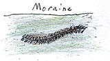
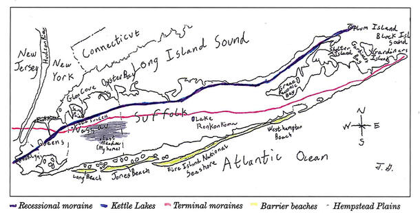
In the center of Long Island, there is a long, hilly ridge called a moraine. Hempstead Plains and most of the south shore is made up of flat, sloping stretches of land that are outwash plains. Lake Ronkonkoma and Lake Success are kettle lakes. Some large boulders are erratics. Two huge erratics on Long Island are Target Rock and Shelter Rock. There are also ground moraines, such as Port Washington peninsula. Just knowing what they are is not enough. How were they formed? Why are they in the spot they are in?
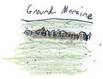
About 22,000 years ago, a glacier crept up and covered the northern half of Long Island. The glacier stopped there for a while. The melting edge dropped rock pieces in a long pile, called a terminal moraine, in the middle of Long Island. The glacier backed up and stopped again, about 20,000 years ago, along the north shore. It piled up some rocks and sand, creating a recessional moraine. Ground moraines are pieces of rock the glaciers drop as they travel. A stack of those pieces created Port Washington peninsula.

Streams of melted ice flowed in front of the glacier, carrying sand, gravel, silt, and clay. They also created flatlands. The land there tends to be fertile because of the silt. The southern half of the island is very different from the northern half because the plains are flat and sandy on one half and there are jagged rocks on the other.
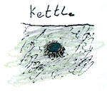
Pieces of the glaciers would break off. Think of them as giant ice cubes denting the ground. The depressions are called kettles, and after filling up with fresh melted glacial water, they are kettle lakes.
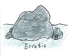
Erratics are boulders that are deposited by glaciers as part of moraines. Glaciers drop them first because they are heavy and can't be carried for very long. There are more on the northern shore because that is where the most recent glacier stopped and dumped some rocks, but they are also all over Long Island. The rocks of Central Park and the Bronx Zoo, which are near Long Island, have skid marks left by dragging boulders. They also have erratics the size of classrooms. Scratches on the erratics show which way the glacier traveled over them.
Most landforms were created by the most recent glacier, Wisconsin, because it changed most of the effects from previous glaciers. It also formed Long Island Sound, a great place for sailing, swimming, and even kayaking. Before that, it had only been a valley filled with water. There was land at both ends. The big ice cubes that broke off fell and melted, creating bays, mostly those on the northern shore. The same falling, melting ice cubes split the East End into the North and South Forks.
The glacier has had a big impact on the shape and features of Long Island. It divided the Island into halves that are very different. The melted glacier water that is underground provides us with a source of drinking water.
Because Long Island is an island, it is always changing. Erosion, storms, and other forces are constantly at work. The waves grind rocks and shells into sand and play a part in shaping Long Island's beaches.
The south shore beaches are sandy because the large waves grind rocks made of minerals like quartz, hornblende, and garnet, and shells like clams, mussels, oysters, conches, quahogs, and moon snails down to sand. The beaches on the northern shore are rocky because the Long Island Sound is more protected from the ocean and has smaller waves, which is why there are so many sailboats there. The waves are not strong enough to grind the rocks into fine sand or cause problems for pleasure boats.
Off the south shore, there are barrier beaches, long strips of beach separated from the island by water. They mostly used to be ocean bottom. Their size and shape are constantly changing with wind forming dunes and blowing them flat. I see dunes when I go to a barrier beach named Jones Beach. I like to climb on them, so I know they are in different positions each time I go. I usually see dunes that are piles of sand blown against the fences. There are also larger secondary dunes farther from the ocean that have been made permanent by planting dune grass and sedges. This environment helps support wildlife such as nesting plovers.
Long Island is always eroded from east to west. That is why inlets on the southern shore are shifting to the west. Sometimes in Jones Beach extra sand is trucked from West End Beach 2 to the east end of the beach and a bulldozer grades it out. When I went to Sands Point Preserve on the north shore, I walked along the top of a high concrete wall. It is one of many retaining walls built to prevent cliffs from washing to sea when it rains and from being eroded by the powerful waves created by storms and local squalls. I also saw a pile of large rocks with pilings extending into the sea. My mom said it was a jetty. Jetties are built to prevent waves from eroding the beach by making the area more protected. I saw similar jetties and a wall at Morgan Park, a park along the coast of Glen Cove. The barrier islands, such as Fire Island, are gradually moving toward the South Shore. Fire Island is moving toward the shore at about 42 centimeters per year.
Storms are another big factor in shaping the landforms of Long Island. Shinnecock Inlet was formed by a hurricane on September 21, 1938. There had been other inlets there in the past, but it took the storm to make it permanent. There are other inlets that have disappeared, such as Zacks, Gilgo, and Muncie Island.
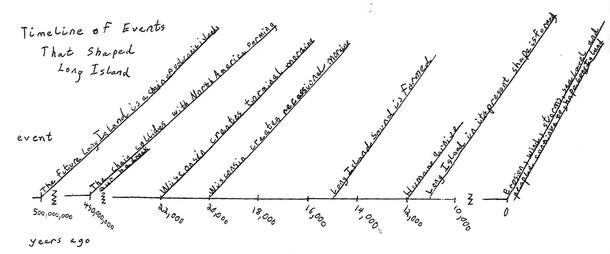
Long Island has come a long way, "like a lump of clay forever being reshaped," says Dan Fagin, who writes about Long Island for Newsday. Only 0.5 billion years ago, the land that is now Long Island was actually part of a chain of volcanic islands. Millions of years ago, the east side of North America was facing south. The future Long Island was in the tropics. It collided with North America 450 million years ago. The volcanic rocks were pushed deep underground and hardened by heat and pressure to form a layer of bedrock. Later, it rose closer to the surface and became our bedrock.
As the continents shifted, the climate grew colder. That and many other factors caused the dinosaurs to die out 65 million years ago. Evidence was found that smaller, three-toed dinosaurs lived on Long Island. After a while, prehistoric animals, like woolly mammoths, that were trying to escape the cold moved in. Twelve thousand years ago Paleoindians came here to hunt the animals. It is hard to believe these ancient animals and people once lived where I live now.
Eleven thousand years ago Long Island finally was formed, after it was pushed together by an ice sheet. The fish-shaped giant sandbar I call home was created. Before that, the landmass that became Long Island must have been totally different. Since it is constantly changing, it might look different in a few years. Different or not, it will always have a special place in my heart.
Life on Long Island has been greatly influenced by its landforms. Long Island's bedrock is too far underground for skyscrapers to be supported by it. That has influenced the kind of buildings that can be erected on Long Island. The fertile plains caused by the glacier made part of Long Island's grasslands. Most of Long Island was grass when Europeans first explored it. The plains were used for farming, especially for potatoes. Much of that land is now a suburb. The first towns built on Long Island were along the shorelines because they were easily accessible by boat for travel and trade, and because fish and shellfish provided a good source of food. The main reason people visit and like to live on Long Island is the beaches. The glacier left behind rocks not normally found on Long Island on the north shore beaches. The smooth beaches on the south shore are nice places to sunbathe, swim and walk because they are long and flat.
The study of Long Island is hard because many places that could have been sites to dig for the fossils and rocks that give clues to the history have been built over and there is not much evidence of other glaciers since the glacier "Wisconsin" wiped out their effects. Also, the climate is too wet to preserve good fossils. As Ralph Lewis, an expert on Long Island Sound, says, "It's like trying to put together a jigsaw puzzle with 70 to 80 percent of the pieces missing." The cliffs of Montauk and the sandpits of Port Washington are two of the few places that still hold clues to the history of Long Island.
There are museums that have exhibits about Long Island's geology, such as Garvies Point Museum in Glen Cove and The Hicksville Gregory Museum. Scientists believe that the average temperature of the world has varied dramatically and that this variation has caused ice ages. If the temperature goes up due to global warming, glaciers will begin to melt, causing the ocean level to rise. I hope that water does not cover Long Island in the near future.
I enjoyed learning about how events millions of years ago, as well as events taking place right now, change the shape and size of my home. The geology of Earth has many effects on me, as well as anyone living on it. I will always love my fish-shaped home.
References
Bailey, Paul. Physical Long Island. Amityville, NY; Long Island Forum, 1959.
Fagin, Dan. "New Find in LI's Jurassic Park". Newsday. 27 October 1998.
Long Island Our Story Canada: Newsday, Inc., 1998: p4.
Lorde, Richard. Personal interview. 2 December 1998.
Murphy, Robert Cushman. Fish-Shape Pamanok. Philadelphia: The American Philosophical Society, 1964.
Newsday. Long Island Our Story. Melville, NY: Online. Available: http://www.lihistory .com/1/glacani1.html: 11 November 1998.
Sesso, Gloria and Regina White. The Long Island Story. Austin, Texas: Steck Vaughn Company, 1984.