From Uplift to Glaciation: The Geological History of the Pikes Peak Region
Part of the Young Naturalist Awards Curriculum Collection.
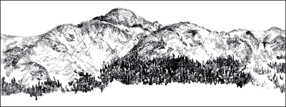
Brittle, amber grasses cast transparent shadows over the pebbly terrain, and a carpet of pine needles crackles beneath my feet, as I scale a steep hill on the Florissant Fossil Beds National Monument in central Colorado. Four-mile Creek shimmers down in the valley below, slicing its path through the fossil-rich shales of prehistoric Lake Florissant and the ancient volcanic deposits surrounding them. The surrounding forest of ponderosa pine shrouds the lower portion of a massive granite form. This is Pikes Peak, one of the many mountain summits that comprise Colorado's Front Range in the southern Rocky Mountains. I sit down on the crest of the hill, absorbing the mountain shapes, muted by the crisp winter light, that ring the horizon around my home: Pikes Peak in the east, Crystal Peak to the north, the long fringe of the Sangre de Cristos in the distant south, and, bisecting the state as part of the Continental Divide, the Sawatch Range in the west.
Living in the shadow of these mountains, I've gradually become acquainted with their habitats and seasons, but the granite soil eroding from Pikes Peak and rounded boulder outcroppings that pattern the landscape remind me that the land's present character is only the most recent facet of an epic saga. Looking now at the rugged, ice-sculpted northern shoulder of Pikes Peak, I sense the vast scale on which events took place during the mountain's existence. For Pikes Peak, my human life represents but a single instant in the eternally changing pageant of geologic time.
Geologists divide Earth's 4.6-billion-year history into four major chronological eras: the Precambrian, which encompasses the first three-fourths of the planet's existence from its formation to the appearance of multicellular life; the Paleozoic, beginning approximately 600 million years ago as complex life began to evolve; the Mesozoic or "Age of Reptiles," lasting from 230 million to 70 million years ago; and the Cenozoic era, which saw the rise of mammalian life and the passing of the ice ages. Each era is further subdivided into periods, which in turn are dissected into epochs.
The opening chapters of the Pikes Peak region's geologic story may be read in its Precambrian foundation, or basement rock. The oldest rocks in the Front Range (1.8 billion-year-old schist and gneiss) reveal evidence of extensive volcanism, metamorphism, and igneous intrusions, indicating that the Precambrian witnessed more tectonic activity than any other time in Earth's history. The foundation rocks of North America are divided into provinces depending on their age and content. About 1.8-1.6 billion years ago, a wide strip of crust containing the Proterozoic Province on which the Front Range stands today accreted (or welded onto) the western edge of the original North American landmass, or craton. The intense tectonic activity also broke up the Precambrian foundation into fault blocks and fissures, ultimately setting the stage for the uplift of the Rocky Mountains at the close of the Mesozoic.
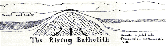
I scoop up a handful of knobby pebbles lying at my feet. Salmon-pink feldspar, black biotite, and opaque gray quartz combine to produce Pikes Peak granite. This hard rock comprises Pikes Peak itself, as well as the coarse gravel eroding from the exposed boulders around me. The first steps in the formation of Pikes Peak occurred 1,050,000,000 years ago, when a tremendous bubble of magma forced its way up into the ancient rocks. This granite injection halted its upward course a few miles below Earth's surface, cooling very slowly to become the Pikes Peak Batholith. Partially uncovered by erosion after the uplift of the Rocky Mountains, the batholith stretches 40 square miles.
I shift my gaze from the mountains to the course of a shallow stream trickling through the valley below. As the water rounds the curves of my hill, it creates a miniature lagoon against the face of a granite boulder. This still sanctuary hosts a variety of microscopic life, such as diatoms and bacteria. Prior to the Paleozoic, single-celled organisms such as these were the only form of life existent. As the Cambrian period opened, more complex creatures began to appear rapidly in the fossil record. This (relatively) sudden influx of multicelled and hard-shelled animals is known as the Cambrian Explosion.

The Paleozoic was a time of restless seas. Although the area in which I live now possesses a dry, almost arid climate, at times in the past it has been underwater. Shallow oceans invaded large portions of North America repeatedly throughout the era. Thick formations of sandstone and limestone are enduring evidence of the tons of sand, silt, and clay deposited by the fluctuating waters. In outcrops of the Harding Formation, an Ordovician sandstone south of Pikes Peak, I have collected fossil scales of primitive agnathid fish, some of the earliest known vertebrates.
The first land-dwelling organisms materialized late in the Silurian. Like early oceanic life, the first terrestrial pioneers were microscopic colonies of cyanobacteria. Gradually these gave way to green algae and, eventually, to primitive vascular plants. The first animal colonists on land were arthropods, whose hard external skeletons made the task of supporting body weight out of water easier.
Slow regional uplift began in the Mississippian period. As the land rose, eroded debris filtered into valleys and lowlands and produced wide, alluvial plains just above sea level. It was on this boundary between earth and water that the first amphibians evolved. The uplift continued into the Pennsylvanian and eventually resulted in the formation of a primordial mountain chain, the Ancestral Rockies. One range, Frontrangia, emerged from Colorado's shallow ocean within 30-50 miles of the present day Front Range.
By the end of the Permian period at the close of the Paleozoic, erosion had leveled the Ancestral Rockies. Colorado became a gently sloping plain, flanked by seas and vast ranks of sand dunes. Reptiles and protomammals (a diverse animal group from which mammals evolved) entered the scene about this time.
I descend through the forest into the valley. Willows line the stream and numerous feathery grasses ripple around my feet. This world is the result of millions of years of evolution, and yet I wonder what other paths it might have taken were it not for the Permian Extinction. The Paleozoic ended with the greatest mass extinction in Earth history, annihilating 96 percent of all marine life, 75 percent of amphibians, many reptile families, and the protomammals. The cause of this global disaster is unknown. It could have been the effects of violent volcanic eruptions in Asia or the sudden habitat reduction resulting from the withdrawal of the shallow seas, or a combination of many factors. Despite this, reptiles endured to diversify and eventually dominate the planet.
The Mesozoic era dawned upon a dry, warm world. Paleozoic seas withdrew for the duration of the Triassic period, and an arid, desert-like climate prevailed. Mesozoic climatic conditions were predominately warm, and 200 million years ago Colorado was a region of tropical temperatures. Triassic sediments accumulated as terrestrial deposits on mudflats and dune fields, today forming fine-grained sandstones and shales exposed along the east side of the Front Range. Popularly known as the "Age of Reptiles," the Mesozoic encompassed the rise of the dinosaurs, their diversification, and eventual extinction.
Thirty miles south of Pikes Peak, I thread my way through the pinon/juniper forest lining the multicolored rock walls of Garden Park, just north of Canon City. Though the air I breathe is dry and cool, 180 million years ago this area was covered by vast tropical floodplains. The bones of the dinosaurs that inhabited these moist lowlands were engulfed by fine-textured mudstones and shales, preserved in what would eventually be called the Morrison Formation. I crouch down at the base of a crumbling, gray-green exposure and sift the shards of shale through my fingers. Pressed within the layers of the hillside is the legacy of Jurassic life. Fossil bones embody the story of a reptile-dominated world, and plant imprints provide trace glimpses into their habitat.
Over the course of the Jurassic, the Ancestral Arctic Ocean or Sundance Sea transgressed over the northern portions of North America four times, bringing with it a gradual change to moist, maritime climatic conditions. At the advent of the Cretaceous period, the northern seas crept down the middle of North America to join another encroaching ocean from the south. These two fused together to create the immense Western Interior Seaway, which bisected the entire continent. The sea laid down deposits of sand and clay thousands of feet thick. For approximately 30 million years, the area in which I stand and, indeed, all of the southern Rocky Mountains were part of an ocean floor patrolled by ammonites and other marine creatures. As the sea withdrew, it uncovered wide flatlands on which the last of the dinosaurs, such as Triceratops, died out.
My eyes glide over Pikes Peak's sharply shadowed ridges. Though the land underwent previous uplifts, the mountain I know did not materialize until the close of the Cretaceous. Like a grand finale to the Mesozoic era, the Laramide Orogeny (mountain-building episode) created not only the Rockies but also the rest of the great chain of mountain ranges stretching from Alaska to South America. Because the land was close to sea level, the young mountains were much lower than they are today, but their identity was secure.
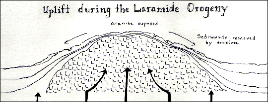
The cause of the upheaval remains elusive, though a wide range of theories attempt to explain it. One of the most likely suggests that plate tectonics was responsible; a long period of accelerated convergence between the Pacific seafloor plate and the North American plate could have caused deformation as far inland as Colorado. This idea is supported by geologic evidence of an increase of Atlantic seafloor spreading around the same time. This would have quickened the rate of collision between the Pacific and North American plates, possibly precipitating an episode of orogeny.
Widespread uplift continued into the early Cenozoic era, and erosion stripped away the sediments overlying the Pikes Peak Batholith. Intensive volcanic activity broke out along the Front Range as another result of the uplift. Volcanoes played an important role in the Tertiary chapter of Colorado's geology, affecting both the character of the Tertiary landscape and our present understanding of it.
Strung out through a shallow valley within walking distance of my home, Four-mile Creek threads its way northward. As I follow its route, I envision the landscape as it must have looked 35 million years ago: a long lake lapped at the edges of the hills, fed by a stream that ran almost parallel to Four-mile Creek. Humid air filtered through the foliage of giant sequoia trees fringing what geologists now call Lake Florissant. The crumbling shale outcrop at the valley's edge that I explore is the result of volcanic ash settling to the floor of the lake. These shales contain an astonishingly detailed record of life in the lake's Eocene existence.
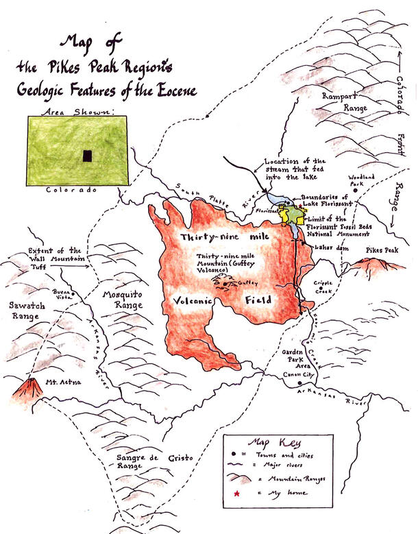
Forty miles southwest of Florissant in the Sawatch Range is the remnant of one of many Tertiary volcanoes, Mt. Aetna. Active during the Eocene, Mt. Aetna produced a hot, glassy material that welded together as it cooled to create a hard tuffstone over a massive area of central Colorado. Known today as the Wall Mountain Tuff, this fine-grained, dove-gray rock provides a datable reference with which to measure the age of Lake Florissant's sedimentary deposits.
Just 15 miles southwest of the Florissant valley is the Thirty-Nine-Mile volcanic field, which extends from Four-mile Creek west to the edge of the Mosquito Range. At its center is a ring of hills encircling the present-day town of Guffey, believed by many geologists to be all that remains of the tremendous Thirty-nine Mile Mountain, or Guffey Volcano. The height of this giant fell within the range of 25-30 thousand feet—some estimates place it higher than Mt. Everest. At the close of the Eocene, the Guffey Volcano disgorged great flows of mud and ash called lahars. Running east through paleovalleys, the lahars sometimes crossed streams, including the one that once ran where Fourmile Creek flows today. The lahar created a natural dam, and the stream backed up some 8 to 10 miles, then turned west for another 2 miles to form an L-shaped lake. Thus Lake Florissant came into being. Just how long the lake existed is unknown, but its habitat, inhabitants, and even clues to the climate of its epoch are beautifully preserved in its surviving shales.
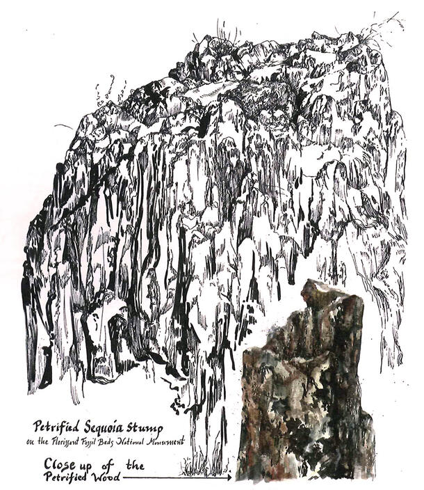
During the Eocene, Colorado's climate would have been "warm temperate," bordering on subtropical, resembling the temperature and seasonality of today's Californian redwood forests. Immense, water-loving Sequoia affinis trees were common all over western North America, and their petrified remains are exposed at Florissant. At the time of the formation of the lake, lahars also surrounded the sequoia trees for up to 15 feet of their height, suffocating the trees but preserving their bases. Five stumps have been excavated at the Fossil Beds, but dozens more have been located by sonar, still buried.
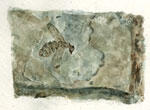
I hold a fragment of shale bearing the imprint of a tiny hymenopteran. From the insect's segmented body to its frail wing membranes, it is perfectly preserved. Such fossils of soft-bodied organisms and plant tissues are rare in most parts of the world, where only hard materials like bones and shells are preserved. The majority of Florissant's fossils, however, are insects and leaves and other plant parts (1,200 insect species and 450 plant species have been recorded). The secret of this extraordinary reversal lies in the ash-cloud eruptions of the Guffey Volcano that followed the lahars into the Florissant valley.
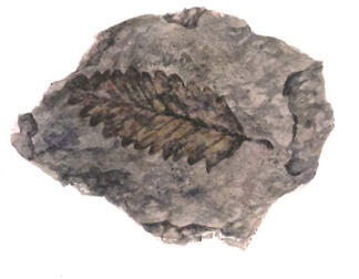
I trace my finger along the paper-thin shale layers, imagining the storms of flour-fine ash that sifted down from the Guffey Volcano. Organisms knocked into the lake by the ash shower were buried quickly in very fine sediments—the two essential components of successful fossilization of fragile organisms. Coarse-grained material deposited over a longer period of time would preserve a skeleton or shell, but any soft parts would be lost. By contrast, the fine ash could preserve the frail membrane of an insect wing in all its delicacy.
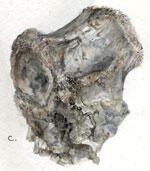
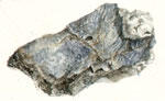
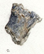
The Dewey Limestone Formation overlies the Nellie Bly Formation. Two samples of this formation were collected. The first sample is of a brachiopod shell wackestone. It was collected from an outcrop in W/2, NE/4, SE/4 Section 10, Township 26 North, Range 13 East, on Bison Road, just east of Bartlesville. It is grayish brown, hard, and argillaceous.
Although insects are abundant in the Florissant shales, very few vertebrates have been found here. A few fossil fish, four birds, and only one mammal (a mouse opossum) comprise the list. One explanation for this proportional scarcity suggests that mammals and birds could have avoided the ash showers by running or flying away, while insects, smaller and more localized, were more susceptible victims.
The volcanic rhythm of eruptions and interludes continued at Lake Florissant until the end of the Eocene, when the Guffey Volcano self-destructed in a spectacular final explosion. This covered the Florissant shales with a concrete-like conglomerate, which sealed off the fossils and protected them from erosion and weathering, until the stream-cutting of today's Four-mile Creek exposed the fossils. Standing before the excavated wall of rock in a private quarry, I can view the entire sequence of alternating paper-thin shales and thicker mudstones, sandwiched between the Wall Mountain Tuff below and the Thirty-Nine-Mile capstone above. These two volcanic layers have been radiometrically dated at 36.6 million and 34.4 million years old, respectively. Thus, Lake Florissant and its fossils are about 35 million years old.
Even after the Guffey Volcano's demise, dramatic volcanic activity persisted in the Front Range. During the Miocene, an uplift of the Pikes Peak region shifted Four-mile Creek's southerly direction to its current northward course.
Until the boundary of the Tertiary and Quaternary periods, Pikes Peak's appearance would have been vastly different from the mountain of today. As the Tertiary ended, widespread uplift elevated both the vast regions of the Great Plains and the Rocky Mountains to their present elevations. Pikes Peak had finally attained its current elevation of 14,110 feet and would soon undergo even greater alterations after the onset of the ice ages in the form of glacial scouring.
Spanning most of the Quaternary period, the ice ages caused glaciers and ice fields to form all across Canada and the northern United States, extending south along the Rocky Mountains. These tremendous masses of ice dramatically altered the land on which they rested. As I look at Pikes Peak's northern face, my eyes are drawn to the wide basin gouged from the granite by the grinding pressure of an ancient glacier. This giant depression, called a cirque, is a typical result of glacial movement. In addition to the cirques that formed at their heads, Pleistocene glaciers carved valleys and furrows out of the mountains as gravity pulled them downward, and left great deposits of debris called moraines as they fluctuated in alternating episodes of ice encroachment and recession. Climatic conditions favorable to full-scale glaciation waned as the Pleistocene faded into the Holocene, although the ice did advance and regress several more times. Holocene glaciers generally formed in pre-existing cirques and basins, deepening and refining the landforms of their predecessors but leaving few of their own. The Holocene began only eleven thousand years ago, and its last two episodes of glaciation provided the finishing touches to the Rocky Mountain's present facade. Pikes Peak's evolution into the mountain I know so well was complete.
I watch a wisp of snow drifting off the summit of Pikes Peak, carried by the wind. The Peak's silent presence inundates the landscape. I imagine the young mountain, newly formed, witness to a world light-years different from the one in which I live. Throughout its existence, Pikes Peak beheld a world of kaleidoscopic change, and the landforms and the underlying sequences of sediments and fossils are a record of that immeasurably rich history. Although the Front Range is at present seismically stable, erosion continues to reshape the mountains, and the forces of orogeny may resurface in the future. Facing the rugged, azure contours of Pikes Peak, I ponder a future that I will never see but one in which the mountains will actively participate.
References
Benedict, Audrey DeLella. A Sierra Club Naturalist's Guide to The Southern Rockies: The Rocky Mountain Regions of Southern Wyoming Colorado, and Northern New Mexico. San Francisco: Sierra Books, 1991.
Chronic, John and Halka Chronic. Prairie Peak and Plateau: A Guide to the Geology of Colorado. Denver: Bulletin 32, Geological Survey, 1972.
Denver Museum of Natural History, Prehistoric Journey Exhibit. Denver Colorado. October 3, 1998.
Drummond, Boyce A. "How old are the Florissant fossils" Harpers Ferry Center, West Virginia: Report to the National Park Service, 1994
Drummond, Boyce A. "The Environment of Ancient Lake Florissant." Harpers Ferry Center, West Virginia: Report to the National Park Service, 1994
Drummond, Boyce A., Director, Pikes Peak Research Station, Florissant, CO. Conversations at Florissant Fossil Beds National Monument: December 2, 8, & 10, 1998.
Epis, Rudy C., Reinhard A. Wobus, & Glenn R. Scott. Geologic map of the Guffey Quadrangle, Park County, Colorado. Washington, DC: U.S. Geological Survey, Map 1-1180 (1:62,500), 1994.
Evanoff, Emmett (ed.) Late Paleogene Geology and Paleoenvironments of Central Colorado, with Emphasis on the Geology and Paleontology of Florissant Fossil Beds National Monument. Guidebook for the Field Trip, 6-8 May 1994, Geological Society of America. Privately published by the author, 1994.
Foutz, Dell R. Geology of Colorado Illustrated. Grand Junction, Colorado: Your Geologist Publishers, 1994.
Hubbard, Richard L. and Danny J. Wyatt. Geology of the Pikes Peak Region, Colorado. Colorado Springs: El Paso Community College, 1976.
Jenkins, John T., Jr. and Jannice L. Jenkins. Colorado's Dinosaurs. Special Publication 35, Denver: Colorado Geological Survey, 1993.
Johnson, Kirk R. and Richard K. Stucky. Prehistoric Journey: A History of Life on Earth. Boulder, Colorado: Roberts Rinehart,1996.
Larkin, Robert P., Paul K. Grogger, and Gary L. Peters. The Southern Rocky Mountains. Geology Field Guide Series. Dubuque, Iowa: Kendall/Hunt.
Meyer, Herbert W. & Laine Weber. "Florissant Fossil Beds National Monument. Preservation of an Ancient Ecosystem." Rocks & Minerals 70: 23 2-23 9. 1995
Noblett, Jeffrey B. Introduction to the Geology of the Colorado Springs Region. Colorado Springs: Colorado College Geology Department, 1984.
Richmond, Gerald M. Raising the Roof of the Rockies: A Geologic History of the Mountains and of the Ice Age in Rocky Mountain National Park. Estes Park, Colorado: Rocky Mountain Nature Association, 1974.
Southern California Consortium. Earth Revealed, Episode 8: Mountain Building. 28.5 min. Burlington, VT: The Annenberg/CPB Collection. Videocassette. 1991